By Cathy Ching
Medill Reports
IRELAND – Ireland and much of Northern Europe was once buried under a large ice sheet tens of thousands of years ago. Today, long after the ice has retreated, the land is still reshaping itself like a mattress slowly rebounding upwards after a heavy weight is lifted. But Southeast Ireland, at the edge of the ice sheet, continues to sink.
The British-Irish Ice Sheet (BIIS) that covered two-thirds of Britain and Ireland at its peak of glacial coverage 27,000 years ago began to melt when global temperatures rose more than 40 degrees during a 10,000-year interval of warming. Consequently, land masses that were compressed in the middle of the ice sheet began to bounce back up due to isostatic rebound as the weight of the ice lifted. But because the southern region of Ireland was at the brink of the ice sheet, it experiences a sinking-like effect relative to sea level instead, explained Sam Kelley, an assistant professor of Quaternary geology at University College Dublin (UCD).
Since the last ice age, sea level has risen 400 feet higher from the ice that melted off land and runoff into oceans. The two remaining ice sheets today in Greenland and Antarctica continue to melt at accelerating rates — at 267 billion tons per year and 136 billion tons per year, respectively — and contribute to 70% of global sea level rise. And they’re more sensitive to warming temperatures than ever before.
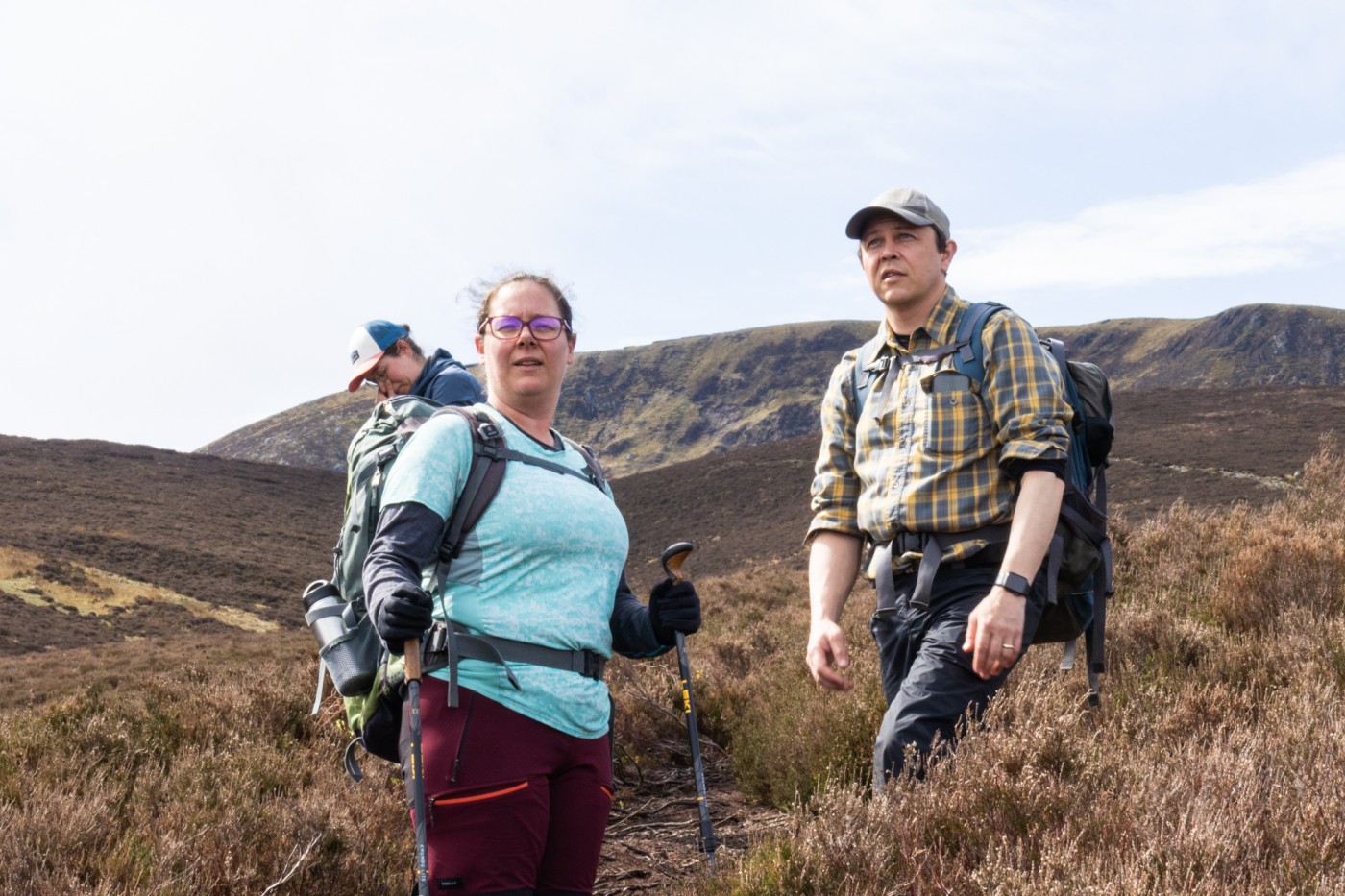
As sea level rise impacts 1 billion people worldwide, the United Nations called it a “global crisis,” especially for low-lying and coastal communities. To find clues in former ice sheets that help scientists connect the dots from past abrupt climate change to the present, Kelley and Assistant Geography Professor Margaret Jackson of Trinity College are co-leading two groups of glacial geologists to examine rock samples from Southeast Ireland through fieldwork and a process called cosmogenic exposure dating.
“The biggest unknown in our sea level projections, at least in this part of the world, is how much ice there was,” Kelley said.
The duo, working with postdoctoral researchers and graduate geology students in the field, are filling in the gaps from modern reconstructions of the BIIS: the timing and pattern of glacial fluctuations and the thickness of the ice sheet.
One primary modern climate model they are hoping to reduce errors for is the BRITICE Glacial Mapping Model from the University of Sheffield in Sheffield, England. Originally published in 2004, the project collected evidence of glacial extent and retreat, and scientists then brought the information together in a database that could then be used to answer questions regarding abrupt climate change, such as sea level predictions. Since its inception, the BRITICE team has updated its data and outside scientists have worked to refine the model and address gaps where they believe it falls short.
For example, scientists behind the BRITICE model suggest the BIIS was almost 1 mile thick and covered all Irish mountain ranges during the last glacial termination, a period of rapid warming that marked the end of the most recent ice age. But Kelley and Jackson said they believe modern constructions of the BIIS both underestimate the timing of ice sheet recession and overestimates the thickness and extent of the BIIS during the peak of the last ice age.
While the thickness of these former ice sheets is “notoriously the hardest thing to constrain,” Kelley said he believes his team has produced “promising results” so far. He said his recent research in Scotland reconstructed the glacial fluctuations and ice sheet thickness of the BIIS in the Cairngorm Mountains, indicating the dating technique that significantly took off in the 1990s is crucial for understanding deglaciated landscapes.
Bringing this technique over to Ireland, Kelley said the data will be invaluable for scientists seeking to understand the future stability of the world’s remaining ice sheets that are both threatened by climate change and pose risks to communities vulnerable to rising sea levels.
“If you can tell (climate scientists) more precisely how thick that ice was, with less assumption, then they can do a much better job of projecting it forward,” Kelley said. “And so it’s useful everywhere because it would refine everyone’s sea level projections.”
Quartz is key to unearthing climate clues
Quartz is the “X” that marks the spot, and earth scientists are on the hunt for the rocky treasure.
To the average person, the gray-colored mineral might seem little more than a pretty stone. But for Kelley and Jackson, quartz is the key to unlocking the secrets of ancient climates.
The rock collects beryllium-10, the primary element that is dissected and analyzed in cosmogenic exposure dating. The radioactive isotope of beryllium only forms in quartz when exposed to high-energy particles called “cosmic rays” that originate from supernova explosions, Jackson explained.
Traveling through the galaxy at near the speed of light, these clusters of particles create beryllium-10 when they hit rocks on Earth’s surface and kick out protons and neutrons in the quartz’s oxygen-16 atoms “like billiard balls being struck,” Jackson said.
“If we can determine the concentration of beryllium-10 or whatever nuclide we’re using in that rock surface,” Jackson said, “we can determine how long ago it got set down.”
But before the scientists prepare the rock samples for dating, they must spend several days per week in Ireland’s southeast mountain range to find the appropriate rocks to date. After all, many factors must be considered to reduce errors in the dating process such as rock type, intensity of cosmic rays, topographic shielding and movement after ice sheet retreat.
Hiking uphill for hours at a time, the geoscientists use an angle grinder and hand chisel to collect about two pounds of granite or sandstone rock samples from the surface of bedrock or glacial erratics, or boulders that have been deposited along the moraines as the BIIS melted.
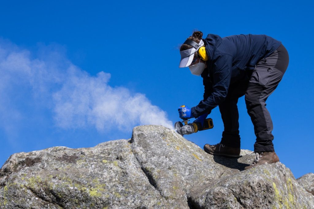
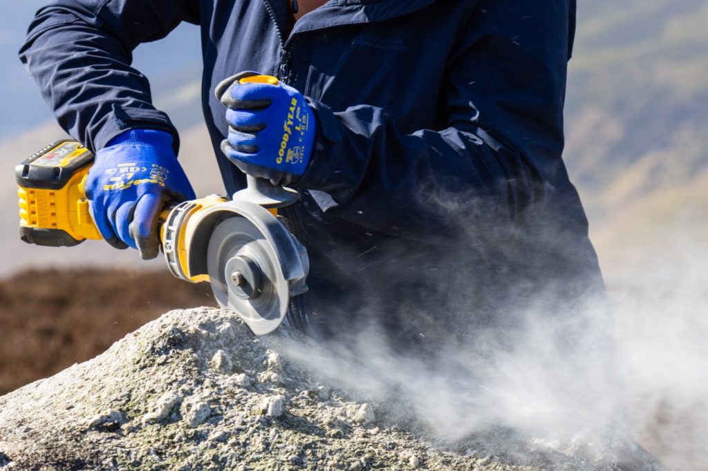
Geoscientists look for rocks that sit at the tallest altitudes in Ireland. That’s because the magnetic field weakens and exposure to cosmic rays grows more intense the higher they climb. There, they continue to search for quartz-rich boulders that have tell-tale signs of being sufficiently eroded and deposited by the BIIS, such as the roundness of a boulder or its placement on bedrock. Otherwise, a boulder that has not been worn away by the ice sheet would accumulate cosmogenic nuclides from pre-glacial times and result in “an age that is way too old,” Kelley explained.
“If a boulder hasn’t eroded,” Kelley said, “it can keep its memories from all its time before.”
Using a clinometer, a tool that determines the cosmic ray shieldings from the boulder’s location, Jackson gathers the measurements of each individual boulder from multiple angles which will be crucial for calculations in the dating process.
Aside from boulders, nunataks also serve as valuable indicators of past ice sheet thickness. Although the idea first struck Kelley while in Scotland, he decided to extend his research to Ireland’s highest elevations, collecting samples of bedrock that have not experienced significant glacial erosion. The nunataks that once protruded above a surrounding ice sheet like an island offer further insights into deglaciation history.
Some trips in the mountain ranges are more productive than others, and they can result from zero to seven samples for each of Kelley and Jackson’s teams. After the collection, the geoscientists head back to UCD to get started with the dating process. The first step is to extract the quartz from the rest of the sample — a task like spotting an unmistakable needle glimmering in a haystack.
In a sample preparation lab at UCD, postdoctoral researchers Helen Dulfer and Apolline Mariotti must compress the samples in a jaw crusher machine and a series of sieves to the right size. While the quartz has mostly been separated from other minerals in the rock, it is still not entirely isolated, so it goes through two weeks of ultrasonic baths made up of nitric, hydrochloric and hydrofluoric acids.
After yet another two weeks in the chemistry lab to purify the sample down to just beryllium with density separation and heating, the samples are the size of dandruff, according to Kelley. The scientists then ship them to the Lawrence Livermore National Laboratory in Livermore, California, where they are dated and eventually sent back to UCD for final calculations.
“We don’t give them all the sample information because we want them to be unbiased in their measurement,” Kelley said. “So if they knew what the answer should be, potentially it would be biased.”
Tackling global sea level rise takes a team effort
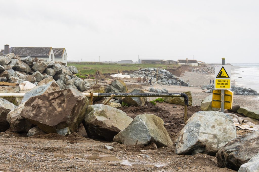
In Wexford, a coastal town in Southeast Ireland, families who have owned homes for generations now face the “immediate risk” of seeing them slide down cliffs into the Irish Sea, according to a Climate Action Regional Office report obtained by Irish news outlet The Journal Investigates.
Slightly north of Dublin, the scenic harbor of Howth could become an island and Bull Island could completely disappear if rising sea levels continue to erode coastlines, according to a “worst case scenario” projection from the Intergovernmental Panel on Climate Change.
As Ireland sits downwind of the North Atlantic Ocean, the country is immediately affected when the ocean system experiences abrupt climate changes, such as increased glacial meltwater from Greenland and Antarctica’s ice sheets that are expanding the volume of the ocean as water warms. But changes in climate are affecting parts of Ireland in different ways.
For example, Irish locals residing in western cities such as Cork, Galway and Limerick are at the highest risk of flooding with increased rainfall. Meanwhile, sea level in Dublin Bay is rising at approximately double the rate of global sea level rise, making residents in this area more vulnerable to both flooding and coastal erosion.
Outside of Dublin Bay, coastal communities in Southeast Ireland, such as Wexford, are experiencing higher rates of coastal erosion exacerbated by taller and stronger tides. That’s because southeastern coastlines are made up of soft glacial sediment, whereas the western coastlines are mostly made up of limestone that is more resistant to high waves from the North Atlantic, explained Robin Edwards, an assistant professor of geography at Trinity College who focuses on physical indicators of sea level change.
“What you’re seeing, particularly where we have the most rapid retreat, is we’ve got a rising sea level, and we’ve got waves then eating away at material that was dumped there during the last glacial (period),” Edwards said. “We’ve been mapping Ireland for hundreds of years, so it’s not a mystery where the stuff is or why it’s eroding away. The challenge is what you do with it.”
While scientists have been constraining bits and pieces of the BIIS for more than a century, Kelley and Jackson’s fieldwork in Ireland’s southeastern mountains brings researchers a step closer to understanding global sea level rise because they are filling in the gaps of modern reconstructions of the BIIS with geochronological techniques. For a while, this was not the case because earth scientists were not working together to understand the limitations of various techniques used to understand deglaciated landscapes and sea level change, Edwards said.
“The debate that existed between the field scientists and the modelers often came down to they were trying to do the same thing, but they were approaching it from very different directions, and they weren’t ending up at the same place,” Edwards said. “And the really interesting information for why they weren’t ending up at the same place was the thing that ultimately helped both get better.”
Additionally, some current sea level models are simulations that have more difficulty replicating past and future events without accounting for geochronology, Jackson said.
“When we start projecting farther out to the year 2300,” Jackson said, “these same climate models, the uncertainty on these projections (and) the potential error bars on these projections get larger and larger and maybe less and less useful.”
Although Kelley and Jackson’s teams are still gathering samples for final calculations, they are thinking ahead: They hope for the data to later be directly interpreted by geophysical modelers for questions or creations of sea level models.
Sarah Bradley, a research associate at the University of Sheffield who helped create two models for the BRITICE project in 2004 and 2017, said she believes Kelley and Jackson’s work to reduce the error bars about the BIIS are feasible. While their data is still in progress, Bradley continues to welcome new scientific data to improve glacial isostatic adjustment models that induce long-term sea level change.
“If you come along and allow someone to question your work in a very open, honest manner,” Bradley said, “that’s how science evolves.”
And these future projections can be used on a global scale. Low-lying islands and coastal communities beyond those in Ireland experience the same heightened environmental challenges that are repercussions of warming temperatures and rising sea levels: coastal erosion, flood risk and stronger storms.
While Kelly and Jackson’s goal is for the data to be directly usable in global sea level projections by geophysical modelers, the pair also hope their work contributes to “science that has direct impact”— particularly in helping to de-risk coastal infrastructure.
“Once the person makes a model of sea level change, then that’s valuable to policymakers, city planners, engineers, everybody, from environmentalists and fishermen and things like that,” Kelley said. “So it’s a bit of a tertiary effect.”
Cathy Ching is a health, environment and science journalism graduate student at Medill. You can follow her on Twitter at @bycathyching.