Far beneath the waves, down in the depths of the Japan Trench — seven kilometres below sea level — lie hidden clues about some of the most powerful earthquakes and tsunamis on Earth.
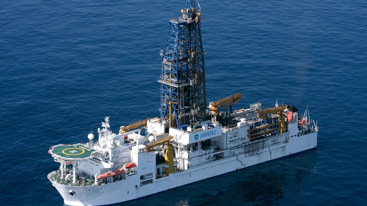
From September to December 2024, Expedition 405 of the International Ocean Discovery Program (IODP) embarked on a four-month long mission to offshore Japan. Aboard the Chikyu — the world’s largest scientific drilling ship — 60 scientists teamed up with experienced drillers to uncover deep-sea sediment cores from beneath the sea floor.
The scientists included sedimentologists like myself, alongside geochemists, micropaleontologists, structural geologists, geophysicists and paleomagnetists. We drilled into a fault zone where only one prior expedition had drilled directly before. IODP Expedition 405 — also called Tracking Tsunamigenic Slip Across the Japan Trench (JTRACK) — is only the second deep-drilling mission to access this area.
This time, we reached and sampled the décollement, or the basal detachment, of the fault that ruptured during the devastating 2011 Tōhoku mega-earthquake. We collected cores that will help scientists better understand how such powerful earthquakes are triggered.
An unexpected slip
On March 11, 2011, the Tōhoku mega-earthquake struck off the northeast coast of Japan, triggering a catastrophic tsunami. At magnitude 9.1, it was the most powerful earthquake ever recorded and the deadliest natural disaster in Japan’s modern history.
More than 18,000 people died. The earthquake severely damaged the Fukushima nuclear plant; there was an estimated US$235 billion in damages. Scientists were surprised not by the scale of the earthquake, but by the location of the largest plate slip that had triggered it: not deep underground, but just beneath the sea floor, at the shallowest part of the plate boundary.
The rupture took place along the Japan Trench, where the Pacific Plate dives beneath the Okhotsk Plate. Until then, this shallow section of subduction zones was thought to slip slowly and quietly.
But during the Tōhoku event, more than 50 metres of slip occurred on a fault that ruptured the sea floor, displacing huge amounts of water and generating the devastating tsunami.
Drilling into the fault
During the IODP 405 expedition, we set out to understand the conditions that make such tsunamis possible.
The Japan Trench provides a natural laboratory to investigate the fundamental processes of tsunamigenic earthquakes that trigger massive tsunamis.
For that reason, we drilled deep into the plate boundary fault, the exact zone that ruptured during the 2011 earthquake. This meant drilling more than 800 metres beneath the seafloor and into the fault itself to recover samples of rocks and sediments.
We also installed a long-term observatory to monitor temperature and fluid pressure at the earthquake’s source, hoping to detect subtle signals locked in the material that once unleashed one of the most powerful earthquakes in history.
Retrieving cores
On board the Chikyu, operations ran 24-7. Every three hours, a new core arrived on deck — a long, cylindrical archive of Earth’s memory. As sedimentologists, we got to work right away peering through the transparent liners with flashlights, scanning for traces of sand, volcanic ash or anything hinting at past geological events.
Each core told a chapter of a story written over millions of years. Layer by layer, they revealed a sequence of faulted, fractured or deformed sediments and rocks. Some contained smectite — a slippery clay mineral known to reduce friction along faults. These are precisely the kinds of materials that can allow tectonic plates to slip easily, even at shallow depths near the sea floor — exactly the kind of setting that could produce a tsunami-generating earthquake.
One of the most thrilling moments came when we hit layers of chert — a hard, glassy rock that marks the transition from deep-sea sediments to oceanic crust. We had reached the décollement zone, the very boundary where one tectonic plate dives beneath another.
In the lab, slicing open the cores revealed something else: beautifully banded colourful clays, tinted in rich shades of chocolate, vanilla and caramel — a natural palette created from geological processes deep within the Earth.
Each new core entered a tightly co-ordinated workflow: scanned by high-resolution, X-ray-computed tomography, tested for physical and chemical properties, then split in half. One half was carefully preserved in a permanent archive, while the other was examined and sampled thoroughly by scientists from various countries and disciplines.
My research focuses on the sedimentary signature of past earthquakes and tsunamis. On the Chikyu, I searched for deposits called homogenite-turbidite sequences. These form when a quake shakes the sea floor, triggering a submarine landslide (the turbidite), followed by a slow rain of fine particles stirred up by the tsunami (the homogenite). These sequences are geological time capsules, helping us estimate how often giant earthquakes have struck in the past.
Fault evolution
The Chikyu returned to the original site drilled soon after the 2011 earthquake. This gave us something rare in geoscience: an opportunity to observe how the fault has evolved over more than a decade. We installed a borehole observatory, deeper and more advanced than any before in this region.
Over the coming years, it will monitor temperature and fluid flow in real time, giving us a window into the living, breathing dynamics of a megathrust fault.
Using this data, scientists will simulate earthquake conditions using numerical models or experiments to test how these rocks respond under pressure. They will analyze the chemistry of the fluids trapped within the fault and use advanced logging tools to build a detailed picture of the fault’s internal architecture.
Others — like myself — will focus on the sedimentary record, deciphering past events to better understand the frequency of earthquakes and tsunamis.
From understanding to preparedness
The Japan Trench is not an isolated case. Subduction zones around the world, from Chile to Alaska to Indonesia, pose similar risks, often just offshore from densely populated regions. If shallow slip can happen there too, then our current models and preparedness strategies must evolve accordingly.
Our goal wasn’t just to understand why the 2011 Tōhoku earthquake happened, but to help prepare for the next one. By improving tsunami hazard assessments and deepening our understanding of mega-earthquake fault behaviour, we contribute to building global resilience.
IODP Expedition 405 marks a major milestone for earthquake and tsunami science. In the coming years, data from the new borehole observatory, along with lab experiments and sediment analyses, will offer unprecedented insights into how these faults evolve and how we can better anticipate and mitigate the impacts of future megathrust earthquakes.
This article is republished from The Conversation, a nonprofit, independent news organisation bringing you facts and trustworthy analysis to help you make sense of our complex world. It was written by: Morgane Brunet, Université du Québec à Rimouski (UQAR)
Read more:
Morgane Brunet receives funding from the European Commission through a Marie Curie Postdoctoral Global Fellowship.