This year, Sindh’s two main barrages — Guddu and Sukkur — have already experienced medium and high floods in July and August. Now, authorities are bracing for another peak flood.
Subhan Ali, a young fisherman, couldn’t catch a single fish from the Indus river on Monday. For hours, he waited at the riverbank that touches the Hussainabad neighbourhood in Latifabad — a town situated in the suburbs of Hyderabad — but his makeshift fishing rod came out empty after every attempt.
“We call it chambi,” he explained to Dawn.com, referring to the makeshift fishing rod — a wooden frame glued together from multiple pieces of wood and a net tied at one end — as we caught up with him at the downstream Hyderabad-Kotri railway bridge on the left bank of the Indus. Ali had tied a piece of foam around his waist with a rope. “This [foam] helps me float in the river as long as I am in there,” he remarked.
Most days, he swims in the river on both sides as well as in the rivercourse, wherefrom the main current of the Indus flows. While entering the river, Ali holds the chambi tight. “As soon as a fish hits it [the net], my hand feels its impact,” he said. “These days we hope to catch the palla fish, a unique species,” he added.
On better days, his catch comprises around five to six small fish, each of which sells for Rs200. Of late, Ali and many other fishermen like him spend long hours inside the river, which has swelled courtesy the improved flows downstream of Kotri.
A lifeline
For people of Sindh, the Indus river holds a special place in their hearts. It is celebrated. It is their lifeline. And this is exactly why, until April this year, a massive anti-canal movement, led by lawyers and political forces, converged in the province. It ended only with the announcement by the prime minister-led Council of Common Interests (CCI) that no new canals would be built over the river until a mutual understanding could be reached among the provinces.
“Floods in Sindh are taken as a positive sign because the province is located at the tail end of the Indus Basin Irrigation System (IBIS)”, explained Sindh Chamber of Agriculture (SCA) vice president Nabi Bux Sathio, a progressive farmer.
“I think the Indus river flows aplenty these days. This is certainly going to benefit the entire area wherefrom the water flows will travel between the three barrages,” he said.
According to Sathio, groundwater in Sindh is generally brackish compared to upper riparian Punjab. “So, these flows will recharge the groundwater to some extent. Likewise, lands in four districts — Tando Mohammad Khan, Sujawal, Thatta and Badin — have lost soil fertility wherever they were located close to the drainage system,” he continued, adding that the flows within the two dykes of the Indus river will help reclaim fertility in all those areas that are located within its reach.
The riverine area of the Indus is inundated whenever such flows start passing the barrages, and they are beneficial for it. At the same time, forests benefit too. According to the forest department’s website, out of Sindh’s total land mass of 14.099 million hectares or 34.84m acres, an area of 1.384mha or 3.426m acres is under the forest department’s control, making up 9.83pc of the total land of the province. Of this area, riverine forests and irrigated plantations cover only 2.29pc, clearly indicating that Sindh is deficient in forestry resources.
These riverine areas also contribute substantially to crop production, with increased flows naturally benefiting the area’s soil. “If water flows increase and are termed high flood, the riverine area, which is considered part of the river, gets inundated.
“It’s absolutely normal, in fact, a lifeline for the river. This helps maintain the ecosystem, biodiversity, forests and aquifer,” explained Mahmood Nawaz Shah, president of the Sindh Abagdar Board (SAB), a community of agriculturalists.
“Therefore, it’s normal that some crops get impacted, which are essentially in the riverine area. The quantum of water is huge, but not abnormal for the river at this time,” he added.
Under threat
On the flip side, the riverine floods trigger relocation and displacement of katcha dwellers. Katcha, a term frequently used in the revenue department’s records, refers to areas located inside the Indus river’s dykes on both sides. Millions of people have lived in these areas for centuries, right from the Guddu to the Kotri barrages.
Recently, the Sindh chief minister announced an evacuation strategy for the population living in the katcha area, considering the variations in river flows passing the three barrages. “It is in our mind to protect lives and livestock under any circumstances,“ CM Murad Ali Shah told a press conference earlier. “Whether the waters are 800,000 [cusecs] and 900,000 or God forbid more than that, our entire katcha area will drown, so we will need to evacuate people from there,” he said.
Shama Bagri, a member of a nomadic community, resides with her family in Palari village, located in the Hussainabad area. A small hut covered with a patchwork of discoloured rags serves as her shelter on the left bank of the Indus river. “We settled here from Tando Mohammad Khan to eke out a living by selling fruits or doing daily wage labour,” said Bagri, whose hut sits atop a small mound a few feet away from the river.
Around 35 Bagri families have settled in this reach of the riverine area. Premo Bagri is another one of them. For now, he is convinced that the river will not cause any harm to him or other families in his community. “When the water flow peaked last year, the river reached a certain height,“ he said, pointing at stones dumped near a water pumping facility, run by a municipal body that lifts supplies of potable water to the city.
For him, the facility serves as a benchmark for when the water level crosses a certain threshold and necessitates temporary shifting to higher ground. “When the water level starts rising, we notice it. I look at the Indus from here and make my own assessment … I am not worried as of today,” he added.
A guessing game
For the past few days, the arrival of floodwaters — downstream Punjab through eastern rivers — has become a guessing game for authorities. Irrigation authorities are making assessments after examining discharges in the eastern rivers of the country. The Chenab river reached a peak of around 1.75m cusecs last week, prompting the Sindh government to prepare for a ‘very high’ or ‘super flood’.
Kotri is the last barrage on the mighty Indus in Sindh. After the river passes the barrage, it enters the Arabian Sea in the coastal district of Thatta through various creeks. Since July, the Indus river has remained in a flood-like state.
This year, Sindh’s two main barrages — Guddu and Sukkur — have already experienced medium and high floods in July and August. Now, authorities are bracing for another flood, with the Sindh chief minister highlighting in his presser on Sunday that while Guddu has already recorded a peak of 550,000 cusecs on Aug 24 in the Indus, the government is preparing for the worst-case scenario.
“Weather patterns can go anywhere. Nobody knows how hill torrents will behave, as was seen in Koh-e-Suleman range when floodwaters were entering Sindh back in 2010,” he told the media in Sukkur. According to him, the Sindh government is preparing itself for a super flood having a quantum of 900,000 cusecs or above under a comprehensive strategy.
Meanwhile, per the irrigation department’s figures, the Guddu barrage in Sindh has a designed discharge capacity of 1.2m cusecs, followed by the Sukkur barrage’s 900,000 cusecs and Kotri’s 875,000 cusecs. The Sukkur barrage, at the time of construction, had a designed discharge capacity of 1.5m cusecs, but due to silt accumulation upstream, 10 of its gates had to be closed, thus reducing its capacity to 900,000 cusecs.
The last time the Guddu and Sukkur barrages passed a super flood was 15 years ago. On August 8, 2010, Guddu had passed a flow of 1,148,200 cusecs downstream after receiving a flow of 1,148,738 cusecs upstream; Sukkur passed 1,108,795 cusecs downstream after having 1,130,995 cusecs upstream the same day. Meanwhile, Kotri barrage passed 939,442 cusecs downstream on Aug 27, 2010, following 964,897 cusecs upstream.
This was not, however, without spelling disaster. The Aug 7, 2010, infamous breach at Tori dyke on the right bank of the Indus upstream Guddu barrage had wreaked havoc for districts on the right bank of the river. Twenty days on, another breach at Kot Almo downstream Kotri barrage had caused further destruction.
Provincial authorities are currently observing flow patterns at the Trimmu barrage and the upstream Panjnad barrage, both located in Punjab. According to Pakistan’s river system mapping, Panjnad barrage is the location where the water from all rivers — Jhelum, Chenab, Ravi and Sutlej — gather and then head for Sindh via the Guddu barrage. At this stage, the flows of the Chenab River are likely to precede the flows of Ravi and Sutlej insofar as arrival at Guddu is concerned.
According to the Flood Forecasting Division’s river flows chart, Trimmu, which was showing a rising trend until last night, is now falling constantly. It has a designed discharge capacity of 875,000 cusecs. It is currently receiving floodwaters generated in Chenab, invariably 10,77,951 cusecs that passed through Khanki and Qadirabad last week. The travel distance for water between Trimmu and Panjnad — the final destination in Punjab before the eastern river flows would enter in the Indus — is around 48 hours. It would then take another 24 hours to reach Mithan Kot, from where they hit the Guddu barrage.
At 4pm on Monday, the discharge downstream Trimmu was recorded at 550,965 cusecs, according to the FFC river flow situation’s chart. But by noon today, the downstream discharge fell to 445,712 cusecs after reaching 516,313 cusecs at 8am. With this flow, Trimmu is perhaps recording a falling trend only to lessen pressure on Guddu ultimately for the authorities.
On the other hand, the Panjnad downstream outflow was recorded at 101,664 cusecs on Tuesday noon, while the Guddu barrage started showing a rising trend at the same time with an inflow of 360,777 cusecs upstream and 345,373 cusecs downstream. A flow that passes downstream at any barrage is considered a flood, considering different categories defined based on river flows.
The storage at Tarbela dam, which remains the principal source of water for Sindh, is being maintained at 1,500 — its optimum level, according to the FFC. Not only this, but the Chashma barrage over the Indus is also holding water to some extent, and its level has risen over the last few days from 647ft to 648ft to help Sindh manage floodwaters from the eastern rivers.
While the flood waters may have reignited hope for farmers and other fishermen in the regions, katcha dwellers wait with bated breath, bracing themselves for yet another year of destruction and displacement.
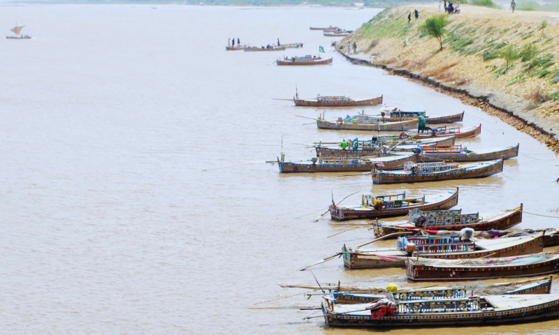
Header image: Several boats line the bank of the Indus River at a time when water had not inundated that part of the riverbed downstream Kotri barrage. — All photos by Umair Rajput