
NSF NCAR scientists develop method that can help prioritize land management practices
Jul 7, 2025
–
by Audrey Merket
NSF NCAR scientists used satellite imagery to evaluate the percentage of forest regrowth post-wildfire across different land conservation categories. (Image courtesy Shima Shams.)
| Impact Statement: Satellite observations may be an efficient, cost-effective way for land managers to evaluate forest recovery after wildfires. |
Using satellite observations to evaluate forest recovery following a wildfire could be an innovative, cost-efficient way to assess the effectiveness of land management practices, according to research published earlier this year.
Scientists at the U.S. National Science Foundation National Center for Atmospheric Research (NSF NCAR) developed a method that cross-references imagery from two NASA satellites with a specialized dataset of land areas developed by the United States Geological Survey (USGS). This enabled the research team to gain powerful insights into what percentage of forests were recovering from wildfires and assess the speed of recovery of different categories of land protection.
Traditionally, recovery of burn areas has been assessed by field work, which is time and labor intensive. Remote sensing offers a quick, low-cost way to assess burned areas.
“We’ve developed a simple framework that could give fire and land managers the ability to easily see what efforts make a difference in forest recovery after a wildfire,” said Shima Shams, NSF NCAR scientist and lead author of the paper, “This method is a quick, cost-effective way to help managers know where to focus funds to get the maximum benefit.”
The research was funded through NSF NCAR’s Advanced Study Program postdoctoral fellowship.
Leveraging datasets
The research team focused on an area in Northern California and Southern Oregon, a region with diverse conservation practices that has experienced increased wildfire activity in the past decade. The first step in testing their method was to identify fire burn events. To detect where fires occurred, the team used data from the Moderate Resolution Imaging Spectroradiometer (MODIS) – an instrument onboard NASA’s Terra and Aqua satellites that produces a variety of datasets using multiple spectral bands covering the entire globe every two days. Then they used imagery from Landsat – a USGS satellite mission that has continuously acquired images of the Earth’s land surface since 1984 – to track how much vegetation came back five years after a fire event.
The scientists then cross-referenced their findings with USGS’s Protected Areas Database. The dataset classifies land areas into one of four broad conservation categories that are based on the extent of long-term biodiversity protection, human intervention, and suppression of natural disturbances.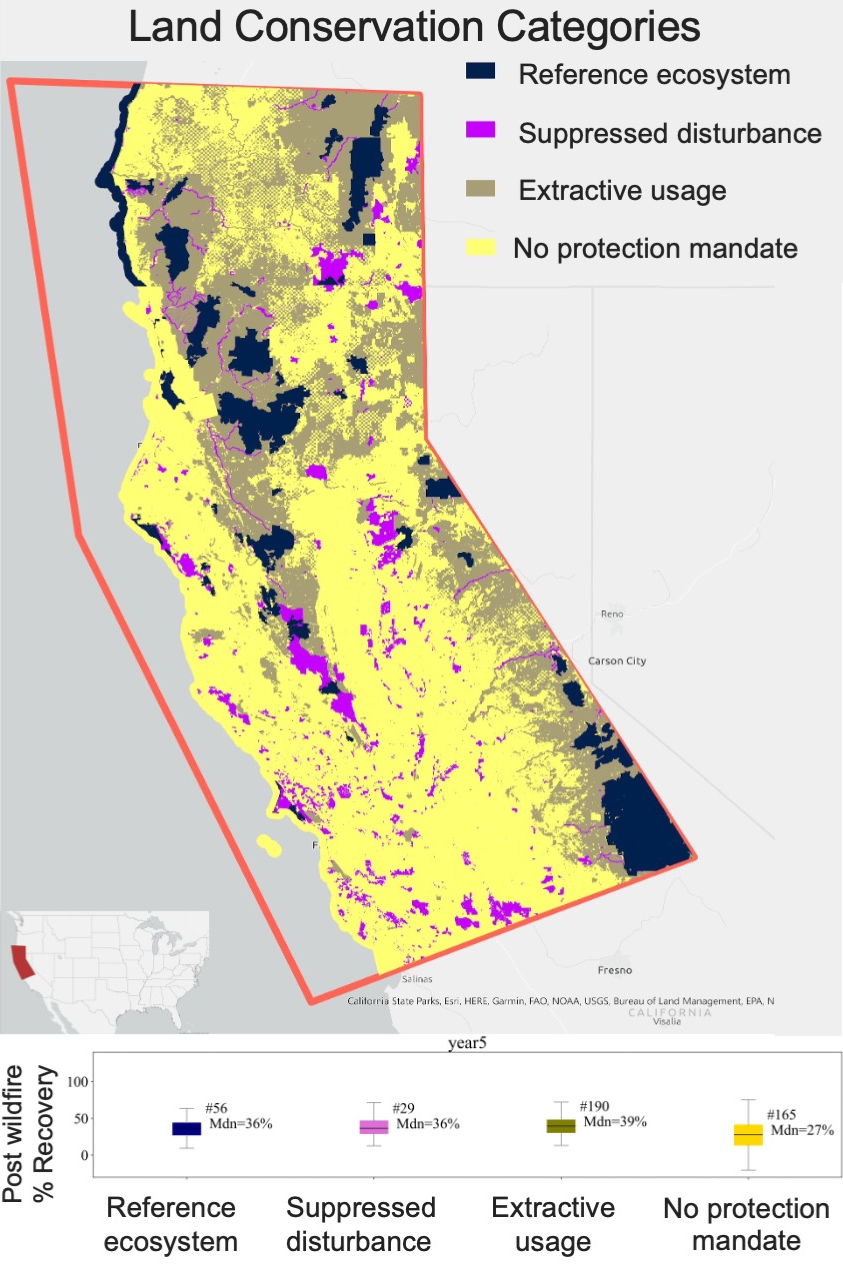
Cross-referencing the remote sensing data with the conservation category allowed the researchers to determine the recovery of forest for each land management practice category. This process showed that areas lacking conservation practices were slower to recover, with unprotected areas recovering around 27% recovery rate at five years compared to 37% across areas with at least some degree of protection.
NSF NCAR researchers also examined fire severity across the different conservation categories and discovered that unprotected areas also experienced more severe fire events. Results showed that not only did areas categorized as “no protection mandate” recover more slowly, they also experienced a 25-47% higher burn severity. This highlights the importance of land management practices for both minimizing initial damage and boosting forest regrowth following a fire.
Additionally, the research revealed differences in recovery based on forest type. The observations showed that evergreen forests benefited the most from protective measures. Knowing which forest types are most affected by conservation practices is an additional piece of information that can help managers develop policy that best utilizes their resources, Shams said.
Collaborating with managers
The authors noted evaluating fire recovery using remote sensing at the resolution they used does not produce information at the same level of detail as field assessments, such as whether vegetation regrowth includes invasive species. Because three out of the four conservation categories used in this study required maintaining biodiversity levels, the researchers knew that the regrowth for those areas was the same as before the fire, but future case studies may need to address this issue in areas where protection for biodiversity is not ensured. However, even in situations where the type of regrowth is not known, this analysis framework still provides valuable, actionable information with far less financial and personnel demands.
NSF NCAR scientists are hoping their next step will be working directly with land and fire managers to adapt the framework to the needs of individual management areas. This approach can help managers see how well different actions work and prioritize investment in strategies that are proven to make a difference.
“Managers need detailed assessment information to know if their decisions and plans were effective and help them know how to adjust their efforts in the future,” said Shams. “Remote sensing is an efficient way to look at the big picture and showcase the efficiency of applied practices.”
See all News