
Key points
- AERONET operates more than 500 ground-based remote sensing sites around the globe measuring atmospheric aerosols.
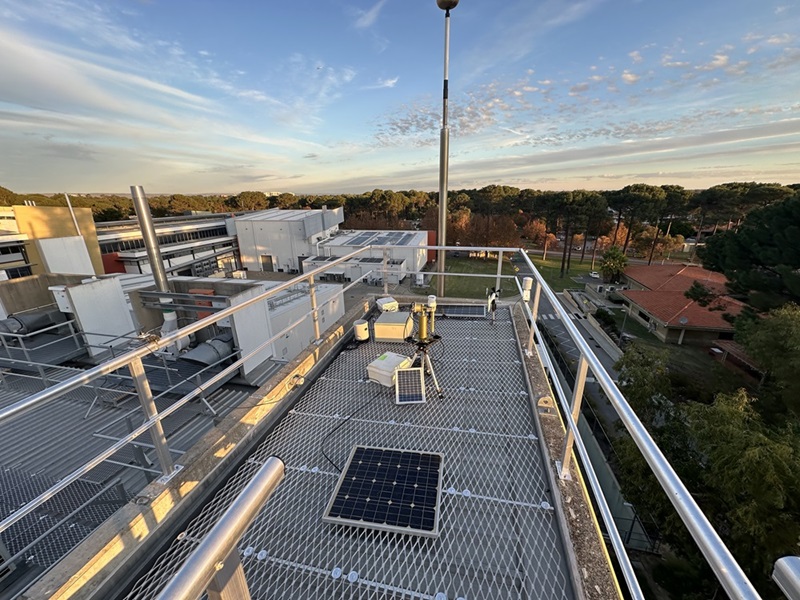
- New atmospheric monitoring instruments recently installed at our Perth site are the latest in the network.
- Atmospheric monitoring is crucial for accurate data from optical satellites.
In October of 1957, the USSR launched the world’s first artificial satellite into orbit around Earth. Today, we’re combining Earth observation with image processing in the search for mineral resources.
Satellites now play a significant role in mineral exploration by providing remote sensing data that helps geologists identify areas with potential mineral deposits.
Remote sensing from satellites
Remote sensing, collecting and studying information from a distance, began seriously with the beach ball-sized Soviet satellite Sputnik 1.
Satellites equipped with multispectral and hyperspectral sensors capture data across various wavelengths of light. Different minerals reflect and absorb light differently, creating unique spectral signatures. This helps geologists map rock types and geological structures, like faults, folds and fractures. This information helps to identify areas which may be worth closer investigation for prospective minerals.
But satellite data is also affected by atmospheric interference from clouds, dust and aerosols. That’s where measurements of atmospheric characteristics become crucially important to process satellite data into useful, reliable and standardised information.
AERONET: a network of atmospheric aerosol measurements
AERONET (AErosol RObotic NETwork) is a global network of ground-based instruments that provides high-quality, long-term observations of aerosol optical properties. It plays a critical role in correcting satellite data, especially for atmospheric and surface reflectance studies.
AERONET operates more than 500 ground-based remote sensing sites around the globe. The robotic network was established more than three decades ago by NASA and the PHOTONS (PHOtométrie pour le Traitement Opérationnel de Normalisation Satellitaire).
In 2024, CSIRO installed new atmospheric monitoring instruments at the Australian Resources Research Centre in Perth. This includes an automatic weather station, air quality sensor, hemispherical sky cameras and a Sun photometer.
This data is now feeding into the international AERONET network of ground-based instruments measuring atmospheric aerosols, ensuring celestial data streams provide accurate observations from our Southern skies.
CSIRO scientists are also using the rooftop installation in Perth to test remote sensing instrumentation prior to installation in other remote locations in Australia.
Seeing through the clouds
Dr Ian Lau is an Earth observation specialist and has worked with AERONET since 2016. His work focuses on extracting mineralogical and environmental information from data.
Ian said accurate remote sensing data relied on identifying and removing data contaminated by clouds.
“Clouds can block direct sunlight, artificially skewing some measurements from optical satellites,” said Ian.
“Cloud cover can also change quickly, causing rapid changes in the measured data.
“With a set of algorithms applied to raw data, a cloud-screening procedure detects and either flags or removes data points that are likely affected.”
Remote sensing for Australian conditions
Australia is a major source of specific atmospheric aerosols, including dust and smoke. Our deserts are the largest dust source in the Southern Hemisphere. Bushfires and burning are commonplace.
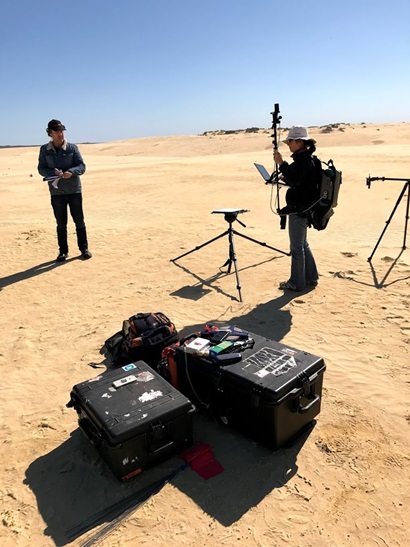
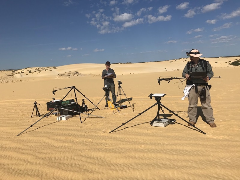
Sitting within the AERONET network is AeroSpan . Operated by CSIRO, Aerospan’s network of automated instruments located to characterise the primary sources of Australian continental aerosols like dust and smoke.
Why satellite calibration/validation is valuable
“Quality control of sensors and ground-based data validation helps us develop realistic products for mineral exploration,” says Ian.
“With satellite calibration data from Southern Hemisphere Earth observation in high demand, good quality data helps researchers better understand our regional conditions.”
Calibration is the process of setting up instruments to provide consistent and accurate measurements. Calibration ensures that the reading from the instrument is consistent with other instruments.
“Calibration links data to known, accurate ground and atmospheric data collected at specific sites,” said Ian.
“With this data verified, we can be confident that the data from satellite remote sensing is also accurate and reliable.”
Ian is part of the team developing a proposed autonomous calibration site for next generation satellite-based instruments capturing highly detailed spectral information.
“Because different minerals reflect light across various wavelengths, we rely on accurate atmospheric correction for optical satellite data,” he said.
“Many smaller satellites launch, often without the resources for rigorous calibration and validation in orbit. These satellites rely on Radiometric Calibration Network (RadCalNet) sites.”
A RadCalNet provides a dataset of traceable and standardised products that researchers and commercial satellite providers use to calibrate and validate the accuracy of optical satellite sensors.
Adding to the network of global calibration sites
Earth observation satellites such as EnMap and PRISMA use sensors operating in the visible to shortwave infrared wavelength range, utilising sunlight reflected off Earth’s surface.
CSIRO is working on commissioning a new RadCalNet site 200 km north of Perth in WA’s Nambung National Park, home of the Pinnacles Desert.
“It makes for an excellent calibration site because it provides a highly reflective and stable surface,” said Ian.
The consistency provided by validated data means it has had accurate atmospheric correction applied and has been precisely wavelength calibrated to detect the presence of certain minerals. This gives a more precise analysis of the spectral signatures of rocks and soils.
“If you’re identifying prospective regions for more detailed investigation, it’s important to have very good quality data and ensure that the products are correct,” he said.
“You don’t want to be predicting there are mineral deposits or vectors towards the mineral deposit when you’ve got some false positives.”
Expanding wavelengths for the future
Instruments such as the ASTER (Advanced Spaceborne Thermal Emission and Reflection Radiometer) satellite typically operate with nine spectral bands, but researchers and scientists are demanding more wavelengths. More wavelengths mean more data.
Hyperspectral satellite imagery, which operates twelve bands across the electromagnetic spectrum, will allow for improved retrieval of atmospheric constituents like methane and carbon dioxide.
“The ASTER satellite had a limited number of specific spectral bands, similar to having only a few TV channels,” Ian said.
In contrast, hyperspectral satellites offer many more ‘channels’, allowing for better differentiation of minerals, improved signal-to-noise ratio, and enhanced coverage.