Biomass refers to the total mass of living plant material in an area, typically measured as dry weight. Forest biomass includes the trunks, branches, leaves, and roots of trees. Biomass is a key indicator of how much carbon is being stored in forests, since trees absorb carbon dioxide from the atmosphere and store it in their tissues. Tracking biomass helps scientists better understand carbon fluxes, assess the impact of deforestation and forest degradation, and improve climate change models. This information also supports international agreements aimed at reducing carbon emissions, such as the Paris Agreement.
“These first images are nothing short of spectacular — and they’re only a mere glimpse of what is still to come,” said Michael Fehringer, ESA’s Biomass Project Manager. “As is routine, we’re still in the commissioning phase, fine-tuning the satellite to ensure it delivers the highest quality data for scientists to accurately determine how much carbon is stored in the world’s forests.”
ESA leaders celebrated the achievement and the collaborative effort behind the mission. “It was extremely emotional because it was the work of hundreds of people,” said Simonetta Cheli, ESA’s Director of Earth Observation Programmes, in an interview with Space.com. “It’s very symbolic of the effort behind the scenes and the potential that this mission has.”
ESA image of the Bolivian landscape at the Beni River in the rainforest. (Image credit: ESA)
One of the first images captures a vibrant region in Bolivia, where rainforest blends into riverine floodplains. This area has experienced extensive deforestation driven largely by agricultural expansion. In the false-color image, green represents rainforest, red indicates forested wetlands and floodplains, and blue-purple highlights grasslands. Cutting through the terrain is the dark, snaking line of the Beni River, one of the last major undammed rivers in the region. “It shows the beauty of our Earth and what we can do to protect it,” Cheli said during a press conference at the Vienna symposium.
A comparison of the same Bolivian region, imaged by both Biomass and Copernicus Sentinel-2, underscores the mission’s unique capabilities. While Sentinel-2 offers natural-color imagery of surface features, Biomass uses P-band radar to penetrate the canopy and reveal the forest’s vertical structure—essential for accurately measuring biomass and carbon content.
A side-by-side comparison of the Bolivian landscape reveals one image captured by the Sentinel-2 satellite and the other by ESA’s Biomass mission. (Image credit: ESA)
Other early images further showcase the satellite’s global reach and scientific potential. Over northern Brazil, Biomass recorded its first image, highlighting diverse Amazonian terrain. Red and pink shades mark wetlands and floodplains, while green depicts denser, higher forests to the north. This level of detail offers new ways to monitor forest health in some of the world’s most ecologically vital and remote regions.
In Indonesia, an image of the mountainous Halmahera rainforest captures the rugged topography shaped by volcanic activity, including the still-active Mount Gamkonora. Despite the dense vegetation, Biomass can reveal subsurface features such as volcanic slopes and forest floor contours, demonstrating its value for both ecological and geological studies.

The first image captured by Biomass. was the Amazon rainforest in northern Brazil (Image credit: ESA)
permalink
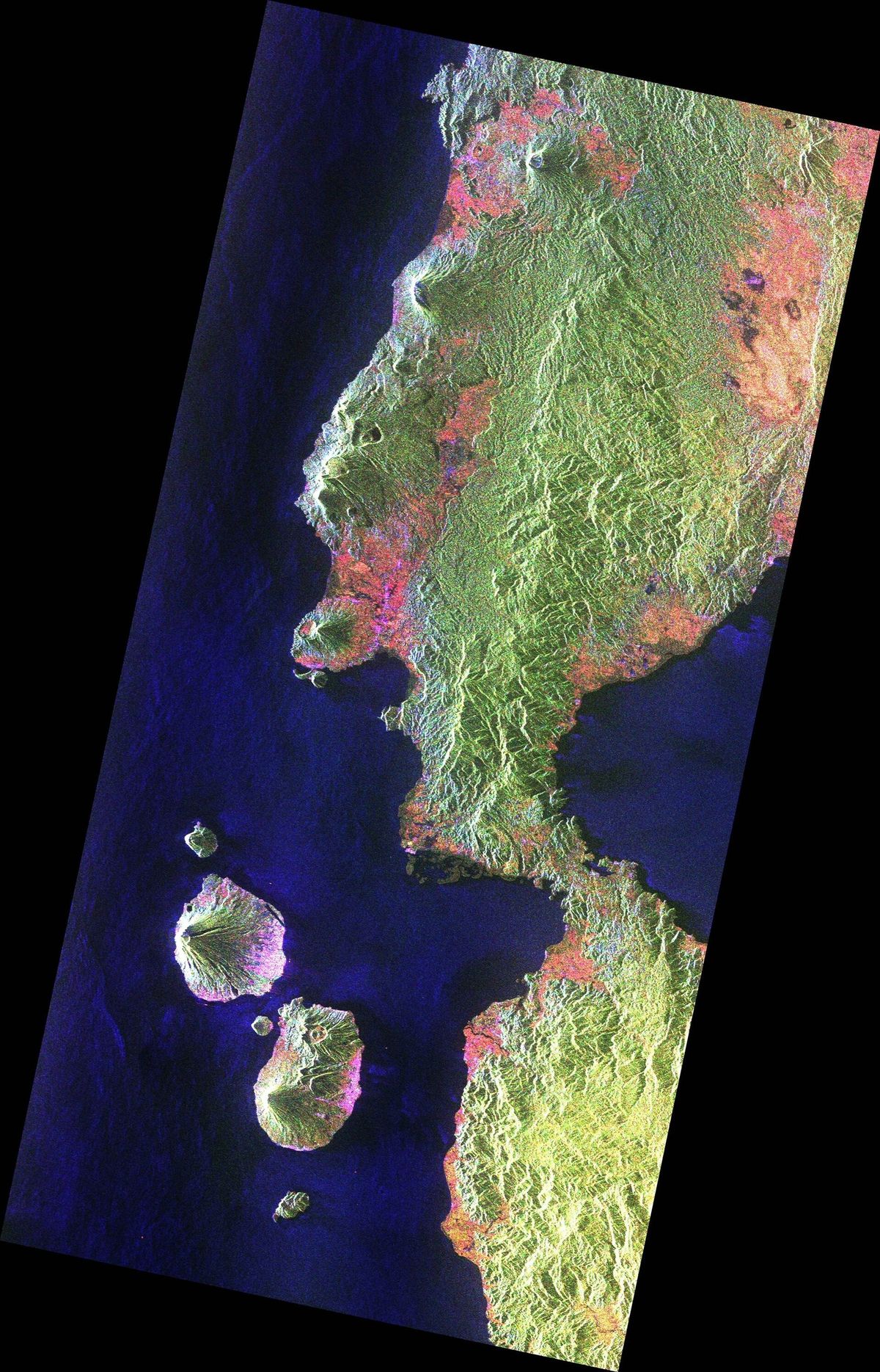
Halmahera rainforest in Indonesia showing the mountains and biomass. (Image credit: ESA)
permalink

The Gabonese landscape (Image credit: ESA)
permalink

Sahara Desert showing detailed sand structures below the sand. (Image credit: ESA)
permalink
From Africa’s Congo Basin, the satellite offers a view of Gabon, where the Ivindo River winds through pristine rainforest. The radar imagery brings clarity to one of the most carbon-dense forest regions in the world, aiding conservation efforts in a region under increasing pressure.
In a striking contrast, an image of the Sahara Desert in Chad reveals hidden ancient riverbeds and geological features beneath the sand. Biomass’s radar can see up to five meters below the desert surface, opening new frontiers in understanding past climates and identifying groundwater resources in arid environments like the Tibesti Mountains region.
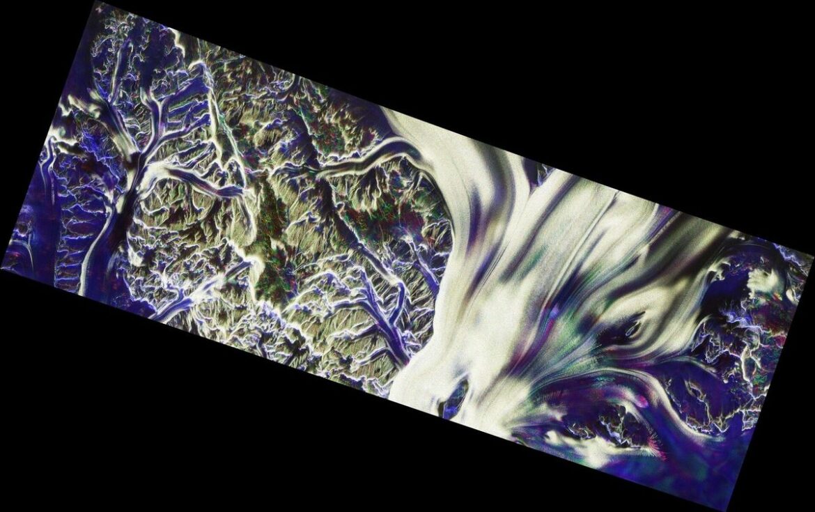
The mission also reaches into polar extremes. A view of Antarctica’s Nimrod Glacier, alongside the Transantarctic Mountains, showcases how Biomass can peer into the ice itself—providing insights into internal glacial structures and movement. This could prove vital for tracking ice sheet stability and predicting future sea-level rise.
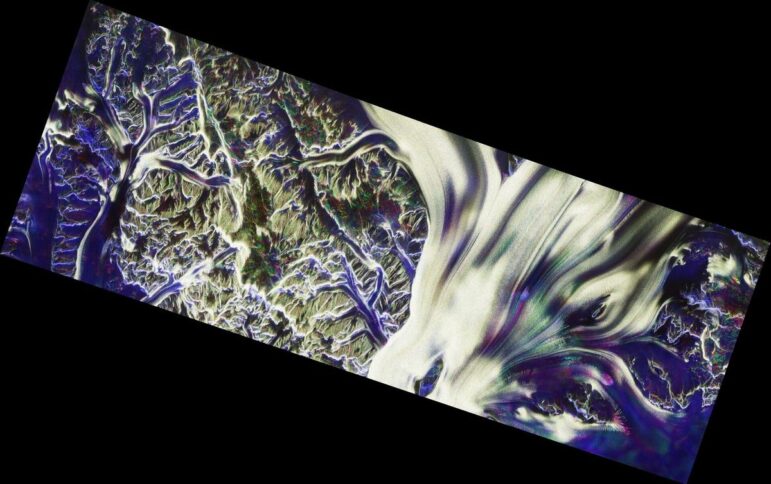
The biomass view of the Nimrod Glacier in Antarctica (Image credit: ESA)
While these initial images are still undergoing calibration and are not yet ready for scientific analysis, they confirm that the satellite is functioning as intended—and potentially exceeding expectations. With a planned five-year mission, Biomass will provide regular, global forest coverage, offering vital data for climate research, conservation planning, and international carbon accounting.
As the satellite moves into full operations, scientists anticipate a flood of high-quality data that could reshape how we observe and protect Earth’s ecosystems—especially its forests, which remain among the planet’s most critical carbon sinks.