In a first, a satellite used AI to spot, think, and act in under 90 seconds, without human help.
The breakthrough came during a recent NASA test of a new technology called Dynamic Targeting, which equips orbiting spacecraft with the ability to autonomously analyze their surroundings and decide, on the fly, where to collect scientific data.
The system allows satellites to look ahead along their orbital path, detect what’s worth observing, like a clear sky or a natural disaster, and point their instruments accordingly.
Smarter skies, sharper science
Developed over a decade at NASA’s Jet Propulsion Laboratory, Dynamic Targeting mimics how a human might interpret imagery.
Instead of simply capturing whatever lies below, the AI processes visual data in real time, identifies meaningful features like clouds or fires, and then chooses whether or not to snap a picture. The recent test completed this entire sequence in under a minute and a half.
This ability to think ahead is especially valuable for Earth-observing satellites, which often struggle with one stubborn obstacle: clouds.
Optical sensors can’t see through them, yet satellites traditionally image whatever is beneath them anyway, cloudy or not, wasting time, storage, and bandwidth on data that scientists can’t use.
With Dynamic Targeting, the spacecraft analyzes look-ahead imagery to detect cloud cover up to 300 miles in advance. If the sky is clear, it captures the surface. If clouds are in the way, it skips the shot and saves its resources for a better opportunity.
“Instead of just seeing data, it’s thinking about what the data shows and how to respond,” said Steve Chien, AI technical fellow at JPL and lead on the project.
“When a human sees a picture of trees burning, they understand it may indicate a forest fire, not just a collection of red and orange pixels. We’re trying to make the spacecraft have the ability to say, ‘That’s a fire,’ and then focus its sensors on the fire.”
Speed, precision, and time
The tech was put to the test aboard CogniSAT-6, a briefcase-sized CubeSat launched in March 2024 and built by UK-based Open Cosmos. To simulate a forward-looking imager, the satellite physically tilted itself 40 to 50 degrees to peer ahead along its orbit.
Once it collected the preview image, onboard algorithms processed it to locate cloud-free regions.
The spacecraft then shifted back to a straight-down position and captured only the clear, usable views.
And it did all this at nearly 17,000 mph.
Now that the system has successfully avoided clouds, NASA’s next tests will flip the script, targeting clouds instead.
Dynamic Targeting will be used to seek out fast-forming, short-lived weather phenomena such as deep convective ice storms, which are notoriously difficult to observe using traditional satellite scheduling.
Specialized algorithms will identify telltale storm structures, and a powerful radar will then “stare” at the storm as the satellite races overhead, collecting high-resolution data for several minutes.
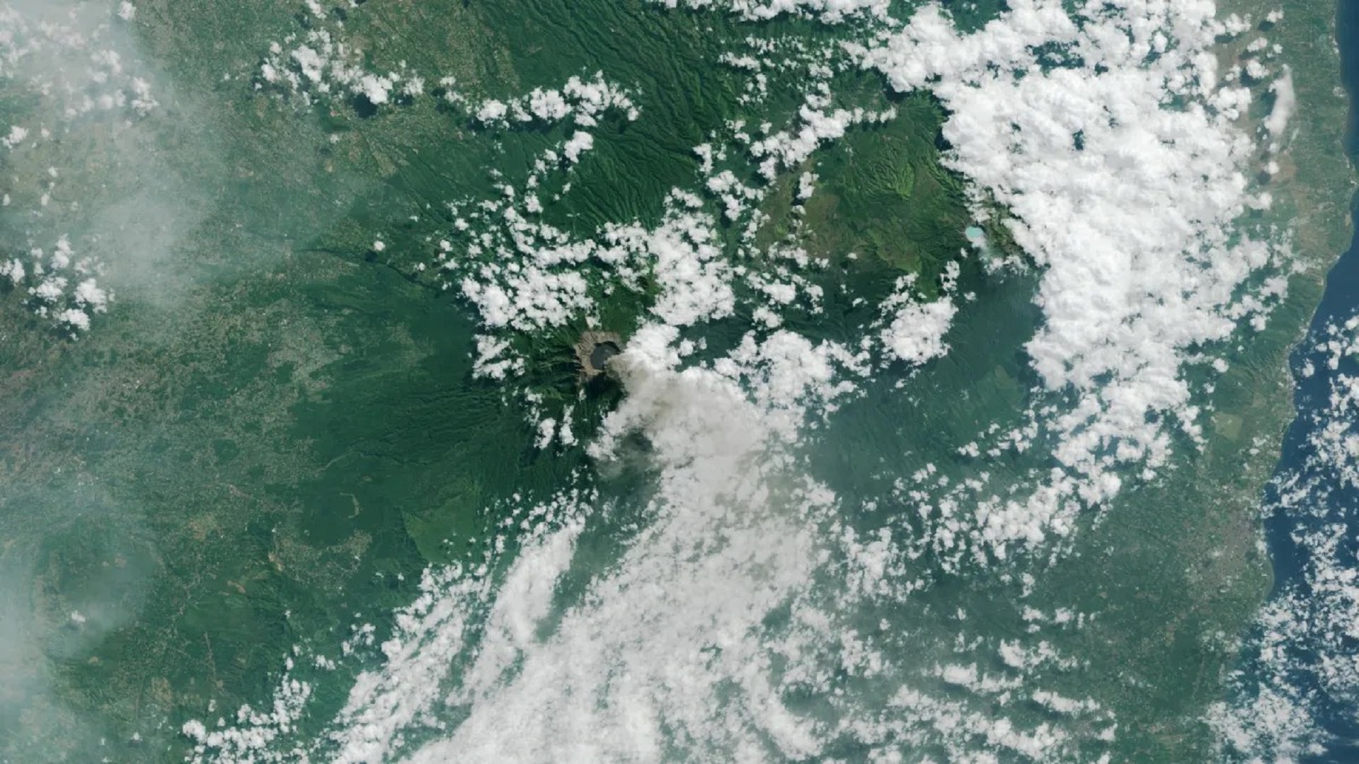
Other tests will involve searching for thermal anomalies, including wildfires and volcanic eruptions.
These events often evolve rapidly, leaving a narrow window to observe them. Dynamic Targeting’s rapid decision-making makes it ideally suited to spot these changes in real time and act before the moment is lost.
Each new application involves training unique algorithms to identify specific visual or thermal patterns, a growing suite of onboard intelligence that makes the spacecraft more responsive and mission-adaptable.
The long-term vision extends well beyond Earth.
NASA is exploring how Dynamic Targeting could aid planetary science missions, like spotting geysers on icy moons, detecting plumes on comets, or focusing on shifting dust storms on Mars.
In fact, the original concept was partly inspired by research done using ESA’s Rosetta orbiter, where similar AI methods helped detect and image plumes erupting from Comet 67P.
There’s even a plan in the works to expand this concept across satellite constellations. In a project called Federated Autonomous Measurement, a leading satellite could detect an event and instantly relay that data to trailing satellites.
The following spacecraft would then reorient and focus on the phenomenon, building a coordinated and dynamic response system in orbit.