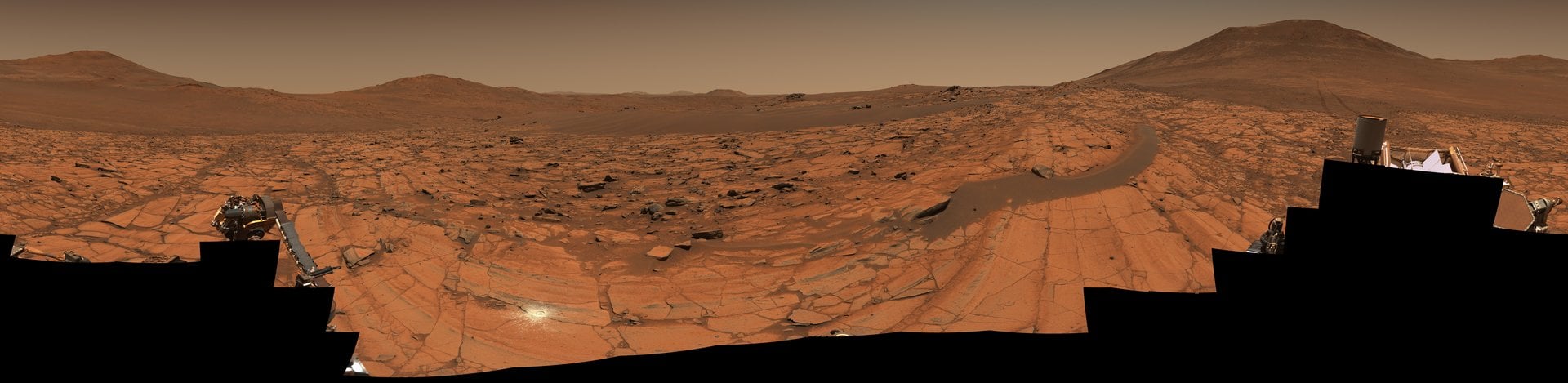
On May 26th, 2025, the skies were clear on Mars above the Jezero Crater, where the Perseverance rover is exploring the planet’s past. The rover’s imaging team took advantage of these conditions to capture the 360-degree panoramic photo shown above, which was stitched together from 96 images taken by the rover’s Mastcam-Z camera. The photo shows a location called “Falbreen,” which shows the rover’s tracks (right side) reaching into the far distance towards its previous stop – a rock outcropping named “Kenmore.” Also visible are rocks and a sand ripple strewn with hills in the distance that are up to 65 km (40 mi) away.
The enhanced-color version (shown below) shows how clear the Martian sky was when the images were taken, though the true-color version shows the actual color of the atmosphere (red, no blue). “The relatively dust-free skies provide a clear view of the surrounding terrain,” said Jim Bell, Mastcam-Z’s principal investigator at Arizona State University. “And in this particular mosaic, we have enhanced the color contrast, which accentuates the differences in the terrain and sky.”
About 4.5 meters (14 feet) away, a large black rock sits on top of a dark, crescent-shaped sand ripple to the right of the rover. Geologists call this type of rock a “float rock” because it likely formed somewhere else and was deposited to its current location, possibly via a landslide, water, wind, or erosion. Regardless, the science team believes it reached its current position before the sand ripple formed, which was likely deposited by wind around it. The bright white circle visible just to the left of the center and near the bottom is an abrasion patch measuring 5 cm (2 inches) wide left by the rover’s drill.
Captured at a location called “Falbreen,” this enhanced-color mosaic features deceptively blue skies and the 43rd rock abrasion (the white patch at center-left) of the NASA Perseverance rover’s mission at Mars. Credit: NASA/JPL-Caltech/ASU/MSSS
This was the 43rd rock abraded by Perseverance since it landed on Mars, which was performed on May 22nd. This process allows the science team to analyze material just below the wind-swept surface of Mars, which is followed by core sample drilling. These samples are then stowed in titanium tubes and left on the surface for future retrieval by astronaut crews or a sample-return mission. The science team is studying the Falbreen site because it is located within terrain that may predate the Jezero Crater itself, potentially making it the oldest terrain Perseverance has ever explored.
Across the entire panorama, roughly halfway in the distance, is the boundary line (contact) between two geologic units, indicated by the transition between lighter-toned and darker-toned rocks. The near, light-colored rocks are rich in olivine, a major component in Earth’s upper mantle, while the more distant, darker rocks are believed to be much older clay-bearing rocks. Said Sean Duffy, acting NASA administrator:
Our bold push for human space exploration will send astronauts back to the Moon. Stunning vistas like that of Falbreen, captured by our Perseverance rover, are just a glimpse of what we’ll soon witness with our own eyes. NASA’s groundbreaking missions, starting with Artemis, will propel our unstoppable journey to take human space exploration to the Martian surface. NASA is continuing to get bolder and stronger.
Further Reading: NASA