With millions displaced and close to a thousand people dead, the Pakistan floods that have been ongoing since June are worryingly reminiscent of the floods that devastated the country in 2022. As the country fights to keep its head above the rising floodwaters, many questions abound. Could the damage so far have been contained? How has climate change contributed? Has India’s release of floodwater — which it had warned about — exacerbated the loss and damage of its lower riparian neighbour? Have the floods been down to bad governance, or a lack of preparedness?
To understand these matters, Dialogue Earth spoke to Muhammad Ehsan Leghari, an expert on water resource management and member for the Sindh province at the Pakistani water regulator, the Indus River System Authority. He discussed the factors that have contributed to the unprecedented floods in Pakistan, what has and hasn’t worked for flood control, and how the country can manage future floods effectively. This conversation has been edited for length and clarity.
What are the main natural and human-made factors that cause recurrent floods along the Indus River and its tributaries, particularly the massive inflows in the Punjab rivers?
As the geographer Gilbert F White noted in 1942, “Floods are ‘acts of God’, but flood losses are largely acts of man”. Human choices in building and managing floodplains can turn natural hazards into disasters. The world, including Pakistan, has been slow to adopt behavioural adjustments alongside engineering, often implementing solutions poorly or unnecessarily.
There are some key factors, generally, regarding the exacerbation of flood impacts. Weak governance turns emergencies into disasters, as seen in recent deaths from floods in Khyber Pakhtunkhwa and other parts of Pakistan. Lack of rational spatial or land-use planning exacerbates urban and riverine flooding. Top-down planning ignores real issues and experiences for most Pakistanis. Political and bureaucratic elites prioritise “brick-and-mortar” development that increases flood and hazard impacts.
Intense monsoons with 200 to 300mm rainfall that had been forecasted, glacial melt and storms, predicted amid northern heatwaves, are natural factors that caused the floods. But human-made factors cannot be ignored: deforestation increases runoff, and urbanisation and encroachments block natural flows. Similarly, the Ravi Urban Development Authority’s paving of floodplains along the Ravi River in Punjab turned absorbent areas into concrete, inviting devastation by turning them into river paths.
Reports like Pakistan’s 2025 Monsoon Prediction, the National Adaptation Plan and the updated Climate Change Policy highlight reduced river capacity from bridges and encroachments. They’ve urged resilience through wetlands and habitat restoration, but have been ignored.
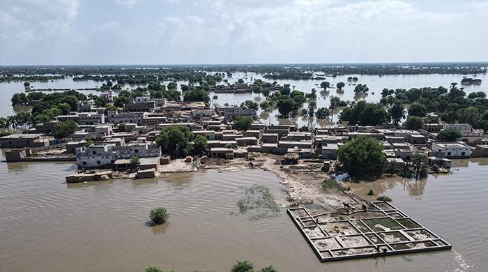
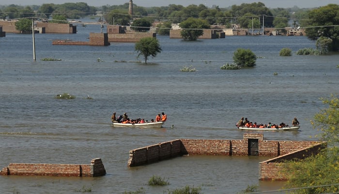
The 2025 inflows have been a result of exceptional upstream rains, Himalayan melt, and India’s dam releases amid heavy rainfall that overwhelmed Punjab’s flatlands, displacing over 2 million people and impacting more 3.6 million, with millions more at risk as waters reach Sindh. This exposes systemic issues: encroached plains displace water onto communities, costing billions. Enforced zoning is needed to break the cycle.
How do glacial melt and changing monsoon patterns contribute to flooding in Pakistan?
They drive unpredictability. Accelerated melting in the Himalayan, Hindu Kush and Karakoram mountain ranges due to warming heightens during heatwaves, synchronising with erratic, concentrated rains that overload the Chenab and Sutlej rivers in Punjab. The province faces riverine overflows, while Khyber Pakhtunkhwa and Sindh see flash and urban floods.
With Pakistan contributing to less than 1% of global emissions, it’s an unjust hit when the country suffers from climate extremes, and in turn, USD 2 billion in losses. Pakistan will have to adapt to this new normal via basin monitoring, integrating it into development paradigms.
How effective are barrages, embankments and canals in managing floods? Do they worsen downstream flooding?
Controlled systems often increase downstream floods and droughts. Punjab mostly managed its headworks (structures at waterway diversion points) and barrages well during 2025 peaks, ensuring safely passing overflows. But Head Panjnad, a barrage where five rivers converge, faced aggressive flood waves, as forecasts by the Flood Forecasting Division had forewarned us. Punjab has rehabilitated most of its barrages; Sindh is upgrading its Guddu and Sukkur barrages.
However, these hydraulic structures can cause bottlenecks, blocking river paths and causing breaches, shifting burdens without adequate warning. Our infrastructure is old and inadequate, fostering a false sense of security for nearby developments. The solution is to shift strategy: live with floods, remove bottlenecks, let rivers flow and nourish floodplains. In addition, we must combine nature-based solutions – such as restoring floodplains — and controlling overflows with modern technology like automated barrage gates and AI forecasting.
What role does silt and sediment buildup in rivers and barrages play in increasing flood risks?
They raise riverbeds. Sediment buildup has elevated the River Indus riverbed, reducing the river’s flood handling capacity by 17.75%. Research has shown that over a 24-year period, this issue, combined with diminished water flow, has decreased the river’s capacity to manage high water levels by nearly half. Without management, sediment buildup causes spills, erosion, breaches and waterlogging.
It’s a cyclical issue: earlier deforestation upstream caused more soil to wash into the river, and the continued failure to manage this sediment has made recent floods, such as those in 2025, much worse, costing billions and impacting thousands of people. We need basin-wide sediment strategies such as integrated watershed management for the Indus, involving India and Afghanistan.
How is climate change expected to alter the intensity and frequency of floods in the Indus River basin over the next 20–30 years?
Climate change will increase the intensity and frequency of floods in the basin over the next few decades. This will mainly be caused by more intense monsoon rains, surging glacier melt and rising sea levels that block drainage in Sindh. It will lead to a new normal of more severe flooding, such as that seen in the 2010, 2022 and 2025 events. That means increased losses and vulnerability, with models predicting even more economic and human damage. Research from the World Weather Attribution supports the overall trend of rising flood vulnerability.
To counter this, a combination of nature-based solutions like restoring wetlands to help absorb floodwaters and engineering solutions are needed, along with improved governance across the entire river basin.
Which groups or regions in Punjab have been most vulnerable to floods, and what local strategies could reduce their risk?
In my opinion, with around four million people affected, the low-lying districts along the Sutlej, Chenab, Ravi and Indus rivers, especially Multan, Jhang, Layyah, Dera Ghazi Khan, and Bahawalnagar, have borne the brunt of recent floods. Urban risk zones include cities like Sialkot, Rawalpindi, Chakwal and Lahore; they face serious flood threats due to drainage and planning challenges.
If we seriously want to safeguard these regions, several measures will have to be taken, such as rebuilding and maintaining concrete embankments, in addition to offering seasonal relocation incentives for local people, deploying mobile and veterinary health units, and mobilising elder-led evacuation plans that draw on ancestral knowledge. Also, empowering communities through bridging skills gaps [in disaster preparedness] can lower risks drastically.
Are flood warning systems in Pakistan good enough, and if not, how can they be improved?
While flood warning systems have gotten better since 2010, they still need improvement. There is a definite lack of preparedness. Currently, one of the main problems is poor communication. Warnings don’t always reach rural areas, and sometimes they aren’t broadcast in local languages or communication channels. We also have accuracy issues: the information is not always reliable or delivered in real time. This is occasionally made worse by a lack of shared data between countries, as seen in the 2025 events involving India, particularly the suspension of the Indus Waters Treaty in April.
To improve these systems, we need to take steps such as using 24/7 monitoring and expanding communication through community radio and text message alerts, and ensure better coordination between all groups involved, especially at the community level. Most importantly, we need to shift from a top-down, reactive approach, to a bottom-up, community-driven one that empowers local people, especially the most vulnerable.
Did India release water that caused Punjab’s floods?
India released excess dam water — including from the Bhakra dam upstream of Pakistan’s Punjab province — worsening monsoon surges. Under the Indus Water Treaty, India should have restored effective communications mechanisms. Pakistan implies that India may have used water as a weapon; however, warnings came earlier through diplomatic channels — the first since the Indus Waters Treaty suspension — on humanitarian grounds.
What should Pakistan prioritise in order to mitigate floods?
Pakistan should prioritise rainwater harvesting, urban water reuse, developing green building codes, restoring its wetlands and floodplains, watershed management and forestation, which together can cut flood peaks by 10-20%. A 2023 Dutch white paper also stresses integrated resilience through three methods: water “reuse” (spreading so as to recharge groundwater) and “retention/reduction” (via cross-drainage and flood channels), as well as the concept of “removing”, or making space for the river through bridge redesign and bund removals, rather than resort to mega-dam projects.
Dams are not the solution. They bring high costs, ecological damage, displacement, and can even worsen floods. We saw this in 2025, when water was released from India’s full dams on the Ravi and Sutlej rivers into encroached plains, and the part
of the Chenab river without dams surged to 1 million cusecs (cubic flow per second). Dams are widely seen as anti-poor, anti-environment and unjust.
Which province has suffered the most in the floods of 2025?
Nationwide, since late-June, there have been over 900 monsoon-related deaths, and as of 11 September, Khyber Pakhtunkhwa has had the most fatalities (504) from flash floods, landslides and cloudbursts. From 14 to 16 August, cloudbursts triggered flash floods in the province. Buner, a district in Khyber Pakhtunkhwa, was worst hit, with at least 380 deaths. Shangla, Swat and Swabi, also in Khyber Pakhtunkhwa, saw similar destruction. Intense rain, deforestation, valley blockages and unregulated construction turned debris deadly, showing an urgent need for mountain-area planning and regulation.
Punjab faces the biggest infrastructure and agricultural losses. Sindh has suffered the longest inundation and displacement due to its flat [and poorly draining] terrain. The terrain drives impacts; Khyber Pakhtunkhwa’s slopes are deadly, while Punjab and Sindh bear economic and geographically spread-out damage [due to being relatively flat]. The whole country is in need of multidimensional recovery.
What are the risks to Sindh, as the lower riparian province?
Sindh’s lower riparian status exposes it to unmanaged upstream floods. But despite that, it lacks input on water releases or land use. In the province, rains amplify to become disasters due to its flat terrain with no flood escape routes, forcing river flows to reclaim floodplains through devastating breaches and prolonged inundation.
What are the biggest governance or policy gaps preventing effective flood management in Pakistan?
The main obstacle is weak governance. More than 400 flood path obstructions were identified in 2011 in a government report I worked on, which mapped over 350 coordinates. Flood responses are often fragmented and reactive, while agencies like the National Disaster Management Authority (NDMA) and its provincial counterparts remain disconnected from communities.
Irrigation departments are under-resourced and politicised, and the 10-year Flood Plan IV has stalled. Spatial planning rules are poorly enforced, and elite development projects by the Ravi Urban Development Authority tend to overshadow public safety. Mandates remain unclear, with overlapping institutions and unresolved inter-provincial disputes. To move forward, Pakistan needs clearly defined roles — who is responsible, when, how and at what cost.
Farahnaz Zahidi Moazzam is a Karachi-based journalist whose work focuses human-centric feature stories, environmental issues like solid-waste management, blue carbon, and water initiatives in South Asia.
This article was originally published on Dialogue Earth website. It has been reproduced on Geo.tv with permission.