Hidden beneath East Antarctica’s thick ice lie secrets from a warmer, ancient world. For decades, scientists have speculated about what lies under this frozen continent.
Researchers have uncovered remnants of vast prehistoric river landscapes buried beneath East Antarctica. These hidden features could help refine predictions about the future of our planet’s ice and oceans.
Plains found under East Antarctica’s ice
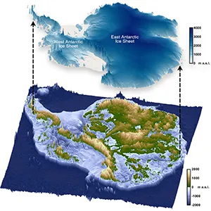
A team led by researchers from Durham University studied radar data across a 3,500 km (2,175 mile) stretch of Antarctica, from Princess Elizabeth Land to George V Land.
They discovered 31 flat surfaces beneath the East Antarctic Ice Sheet (EAIS). These surfaces, preserved under ice as thick as 2,500 meters (8,200 feet), appear as coherent, low-relief plains.
The study showed that they were once part of a single fluvial landscape that formed after East Antarctica separated from Australia.
The researchers used data from four major airborne surveys. Their detailed analysis revealed gently sloping surfaces with consistent elevations, now separated by deep glacial troughs.
These plains dip coastward and cluster around 200 to 450 meters (656 to 1,476 feet) above present sea level, once adjusted for ice unloading.
Origins in ancient river systems
The scientists interpret the surfaces as remnants of ancient river plains. After the continents split, rivers eroded the land to a base level, creating a vast, seaward-sloping plain.
These features closely resemble those along the Australian coast, which formed through similar processes.
According to the team, the plains likely developed between 80 and 34 million years ago, after the breakup and before widespread glaciation.
“Information such as the shape and geology of the newly mapped surfaces will help improve our understanding of how ice flows at the edge of East Antarctica,” said Dr. Guy Paxman.
“This, in turn, will help make it easier to predict how the East Antarctic Ice Sheet could affect sea levels under different levels of climate warming in the future.”
Surfaces in East Antarctica survived ice
Remarkably, these river-carved surfaces have survived beneath the ice for over 30 million years.
They were not destroyed by glacial erosion. Instead, fast-moving ice carved deep troughs between them, leaving the flat surfaces mostly intact. These areas likely remained frozen at the base, which reduced erosion.
Research shows that today’s fast-flowing glaciers, such as Totten and Denman, move through these deeper troughs.
Meanwhile, the ice above the flat surfaces is slow-moving and cold-based, further preserving the landscape.
Bedrock confirms river, not ice origins
The researchers found that the surfaces cross different geological provinces, including crystalline gneisses and sedimentary rocks.
This confirms that the surfaces did not form due to rock boundaries. They formed from river erosion, not through ice or marine processes. Their consistency in elevation and slope supports this.
Some of these surfaces now align with exposed regions like the Bunger and Vestfold Hills. These exposed features show signs of glacial scouring, but not enough to erase the original fluvial structure.
The research suggests limited modification by ice, mostly during the Oligocene or early Miocene periods.
Influence on future ice sheet retreat
These buried plains are not just ancient relics. They still shape the modern flow of the EAIS. Ice moves fastest through the troughs, not over the flat surfaces.
The researchers argue that these plains could anchor ice during future warming events, potentially forming grounded ice rises.
“This study brings the jigsaw pieces of data together, to reveal the big picture: how these ancient surfaces formed, their role in determining the present-day flow of the ice, and their possible influence on how the East Antarctic Ice Sheet will evolve in a warming world,” noted Professor Neil Ross.
Slowing East Antarctica’s ice loss
The presence of these elevated plains buried under the ice could slow the retreat of grounding lines.
If ice shelves collapse during warming, some grounded ice might remain over these surfaces. This would reduce ice loss into the ocean. In regions like Law Dome, some surfaces already host ice rises, which help anchor and stabilize the inland ice.
However, current large-scale ice sheet models often overlook these features. Their resolution is too low to capture how these plains affect grounding-line behavior.
The authors urge more drilling and high-resolution modeling to better understand the role of these features.
This could change sea level predictions
East Antarctica holds about 90 percent of Antarctica’s ice. If this ice sheet melted, it would raise sea levels by 52 meters (171 feet). Improving how we model its behavior is essential.
These hidden landscapes offer a new constraint on where ice will likely remain stable.
The study’s detailed data on elevation, slope, and bedrock composition provide critical insights. They help scientists to project more accurately the responses of the EAIS to future climate change.
The findings highlight the value of geophysical surveys in revealing what lies beneath the ice and how it might shape our future.
The research appears in Nature Geoscience and is supported by institutions in the U.K., Germany, China, and Australia.
—–
Like what you read? Subscribe to our newsletter for engaging articles, exclusive content, and the latest updates.
Check us out on EarthSnap, a free app brought to you by Eric Ralls and Earth.com.
—–