Submarine canyons are deep, large-scale incisions found on most of the world’s continental margins. In Antarctica, they are widespread features driving oceanographic processes with significant implications for global climate and circulation. The understanding of their oceanographic, climatic, geological and ecological significance is limited by the detail, accuracy and extent of canyon inventory. In a new study, scientists from University College Cork and the Universitat de Barcelona aimed to create the best possible catalog of Antarctic submarine canyons and gullies. They identified 332 drainage networks with 3,291 stream segments, nearly 5 times the number of canyons identified in previous studies.
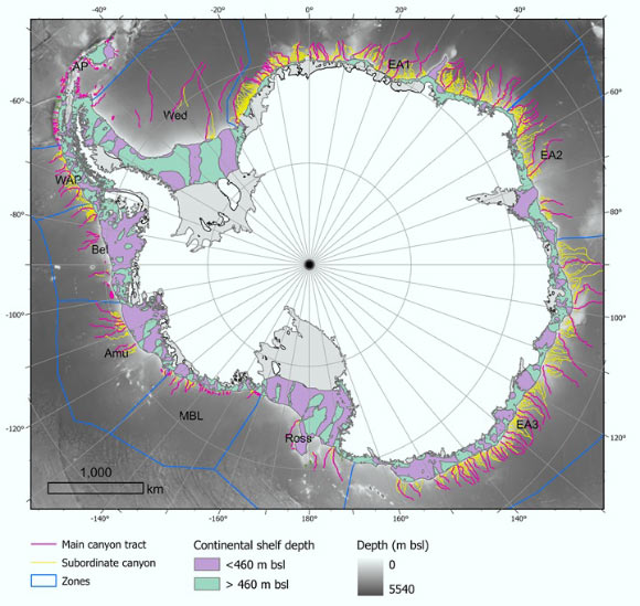
This map shows 332 submarine canyon networks on the seafloor of the Antarctic continent. Image credit: Riccardo Arosio & David Amblas, doi: 10.1016/j.margeo.2025.107608.
Submarine canyons are common geomorphic features that occur on all continental margins.
They are steep-sided, generally V-shaped valleys with fairly narrow, and sinuous morphologies, rugged slopes, beginning at the edge of the continental shelf or on the continental slope, and ending at the continental rise or abyssal plain.
Confined channels less than 10 km long, generally on the order of tens of meters deep and linear in plan view, are known as submarine gullies, and are commonly found alongside or within canyon systems on the continental slope.
Submarine canyons transport sediments and nutrients from the coast to deeper areas, they connect shallow and deep waters and they create habitats rich in biodiversity.
Scientists have identified some 10,000 submarine canyons worldwide, but because only 27% of the Earth’s seafloor has been mapped in high resolution the real total is likely to be higher.
And despite their ecological, oceanographic, and geological value, submarine canyons remain underexplored, especially in polar regions.
“Like those in the Arctic, Antarctic submarine canyons resemble canyons in other parts of the world,” said Dr. David Amblàs, a researcher at the Universitat de Barcelona.
“But they tend to be larger and deeper because of the prolonged action of polar ice and the immense volumes of sediment transported by glaciers to the continental shelf.”
For their study, the authors used Version 2 of the International Bathymetric Chart of the Southern Ocean (IBCSO v2), the most complete and detailed map of the seafloor in this region.
It uses new high-resolution bathymetric data and a semi-automated method for identifying and analyzing canyons that was developed by the authors.
In total, it describes 15 morphometric parameters that reveal striking differences between canyons in East and West Antarctica.
“Some of the submarine canyons we analyzed reach depths of over 4,000 m,” Dr. Amblàs said.
“The most spectacular of these are in East Antarctica, which is characterized by complex, branching canyon systems.”
“The systems often begin with multiple canyon heads near the edge of the continental shelf and converge into a single main channel that descends into the deep ocean, crossing the sharp, steep gradients of the continental slope.”
“It was particularly interesting to see the differences between canyons in the two major Antarctic regions, as this hadn’t been described before,” said Dr. Riccardo Arosio, a researcher at University College Cork.
“East Antarctic canyons are more complex and branched, often forming extensive canyon-channel systems with typical U-shaped cross sections.”
“This suggests prolonged development under sustained glacial activity and a greater influence of both erosional and depositional sedimentary processes.”
“In contrast, West Antarctic canyons are shorter and steeper, characterized by V-shaped cross sections.”
“This morphological difference supports the idea that the East Antarctica Ice Sheet originated earlier and has experienced a more prolonged development,” Dr. Amblàs said.
“This had been suggested by sedimentary record studies, but it hadn’t yet been described in large-scale seafloor geomorphology.”
“Thanks to the high resolution of the new bathymetric database — 500 m per pixel compared to the 1-2 km per pixel of previous maps — we could apply semi-automated techniques more reliably to identify, profile and analyze submarine canyons,” Dr. Arosio said.
“The strength of the study lies in its combination of various techniques that were already used in previous work but that are now integrated into a robust and systematic protocol.”
“We also developed a GIS software script that allows us to calculate a wide range of canyon-specific morphometric parameters in just a few clicks.”
The team’s work appears in the journal Marine Geology.
_____
Riccardo Arosio & David Amblas. 2025. The geomorphometry of Antarctic submarine canyons. Marine Geology 488: 107608; doi: 10.1016/j.margeo.2025.107608