The International Finance Corporation (IFC), Standard Chartered Bank Pakistan, and Engro Fertilizers have collaborated on a financing arrangement designed to mobilize long-term local lending for Pakistan’s agriculture sector.
The deal involves an unfunded partial credit guarantee of up to PKR 33.6 billion from IFC, which reduces credit risk for Standard Chartered as it provides long-tenor rupee financing to Engro. This innovative mechanism aims to lower borrowing costs for Engro, which will use the funds for capital expenditures, including plant maintenance, and ensure stability in urea supply during peak agricultural demand.
The arrangement is significant as it marks IFC’s first local-currency investment in Pakistan, allowing Engro to secure long-term financing without the need for foreign-currency debt, a key benefit given the current volatility in exchange rates and external financing conditions. The financing structure is also supported by the IFC-Canada Facility for Resilient Food Systems, which absorbs initial risk, making the arrangement more attractive to commercial lenders.
While the deal does not address broader structural issues in Pakistan’s agriculture, such as inefficient logistics or low productivity, it demonstrates the potential of risk-sharing tools to attract domestic capital for long-term infrastructure investment. Market analysts expect similar financing models to become more common as local-currency financing gains favor over foreign debt in the current macroeconomic climate.
Recall of Puckator little tractors tableware set for children as they are unsuitable for microwave use
Tuesday, 23 December 2025
Alert Summary
Category 1:
For Action
Alert Notification:
2025.67 Update 1
Product Identification:
Puckator Little Tractors Tableware Set; barcode number: 5055071785467
Country Of Origin:
China
Message: Further to food alert 2025.67, the recall has been extended to cover Puckator little tractors tableware set.
The above children’s tableware sets are being recalled as they contain a material which should not be microwaved. The product label states that the implicated products are suitable for microwaving.
Action Required:
Manufacturers, wholesalers, distributors, caterers & retailers: Retailers are requested to remove the implicated product from sale and display a recall notice at point-of-sale.
Consumers: Consumers are advised not to use the implicated product.
You don’t have permission to access “http://www.mastercard.com/us/en/news-and-trends/press/2025/december/mastercard-spendingpulse–savvy-shoppers-and-e-commerce-fuel-u-s.html” on this server.
BALTIMORE – December 23, 2025 – Constellation Energy Generation, LLC (“Constellation”), a Pennsylvania limited liability company, announced today that it has extended the expiration date of (A) its previously announced private offers to exchange any and all of the outstanding (i) 4.625% Senior Unsecured Notes due 2029 (“Existing Unsecured 2029 Notes”), (ii) 5.000% Senior Unsecured Notes due 2031 (“Existing Unsecured 2031 Notes”) and (iii) 3.750% Senior Secured Notes (“Existing Secured 2031 Notes” and, together with the Existing Unsecured 2029 Notes and the Existing Unsecured 2031 Notes, the “Calpine Notes”) issued by Calpine Corporation, a Delaware corporation (“Calpine”), held by eligible holders for, to the extent held by eligible holders, newly issued (i) 4.625% Senior Unsecured Notes due 2029 (“New Unsecured 2029 Notes”), (ii) 5.000% Senior Unsecured Notes due 2031 (“New Unsecured February 2031 Notes”) and (iii) 3.750% Senior Unsecured Notes due 2031 (“New Unsecured March 2031 Notes,” and, together with the New Unsecured 2029 Notes and New Unsecured February 2031 Notes, the “Constellation Notes”) by Constellation having the same interest payment dates, maturity dates and interest rates as the Calpine Notes (each, an “Exchange Offer”, and collectively, the “Exchange Offers”) and (B) Constellation’s related solicitation of consents, on behalf of Calpine (the “Consent Solicitations”), to adopt the Proposed Amendments (as defined below), pursuant to the terms and subject to the conditions set forth in an exchange offers memorandum and consent solicitations statement, dated December 9, 2025 (the “Offering Memorandum”).
Constellation has extended the expiration date of the Exchange Offers and Consent Solicitations, which was originally scheduled to be 5:00 p.m., New York City time, on January 8, 2026, to 5:00 p.m., New York City time, on January 12, 2026, unless such date is extended or earlier terminated (such date and time, as they may be extended, the “Amended Expiration Date”). Constellation reserves the right to terminate, withdraw, amend or extend the Exchange Offers and Consent Solicitations in its sole discretion, subject to the terms and conditions set forth in the Offering Memorandum. The withdrawal deadline remains unchanged and has passed. As a result, any Calpine Notes tendered after 5:00 p.m., New York City time, on December 22, 2025 (the “Early Tender Deadline”) and on or prior to the Amended Expiration Date may not be withdrawn and the related consents delivered in the Consent Solicitations may not be revoked, except in certain limited circumstances where additional withdrawal rights are required by law.
Constellation also announced that it has received, on behalf of Calpine, the requisite consents to amend the Calpine Notes and the indentures governing the Calpine Notes (the “Calpine Indentures”) to eliminate substantially all of the restrictive covenants and events of default, other than payment-related and bankruptcy-related events of default (collectively, the “Proposed Amendments”), based on the early tender results. As of 5:00 p.m., New York City time, on the Early Tender Deadline, (i) $646,822,000 in aggregate principal amount of Existing Unsecured 2029 Notes, representing approximately 99.51% of the aggregate principal amount of Existing Unsecured 2029 Notes outstanding, had been validly tendered and not validly withdrawn (and consents thereby validly given and not validly revoked), (ii) $846,337,000 in aggregate principal amount of Existing Unsecured 2031 Notes, representing approximately 99.57% of the aggregate principal amount of Existing Unsecured 2031 Notes outstanding, had been validly tendered and not validly withdrawn (and consents thereby validly given and not validly revoked) and (iii) $794,462,000 in aggregate principal amount of Existing Secured 2031 Notes, representing approximately 88.27% of the aggregate principal amount of Existing Secured 2031 Notes outstanding, had been validly tendered and not validly withdrawn (and consents thereby validly given and not validly revoked).
Constellation intends for Calpine and the trustee for the Calpine Indentures to execute and deliver supplemental indentures to amend the Calpine Indentures giving effect to the Proposed Amendments. However, the Proposed Amendments will only become operative on the settlement date of the Exchange Offers, which is expected to occur on or about the third business day after the Amended Expiration Date, unless Constellation extends or terminates the Exchange Offers (such date and time, as the same may be extended, the “Settlement Date”), and no earlier than the consummation of the previously announced merger transaction contemplated by that certain Agreement and Plan of Merger, dated as of January 10, 2025, by and among Constellation Energy Corporation and Calpine (the “Transaction”). Consents of the holders of at least 66-2/3% in aggregate principal amount of the Existing 2031 Secured Notes have been received, and therefore the Proposed Amendments will also provide that the Existing Secured 2031 Notes Indenture will be amended to eliminate the security interest granted thereunder and to release the collateral securing the Existing 2031 Secured Notes.
For each $1,000 principal amount of Calpine Notes validly tendered in the Exchange Offers, not validly withdrawn by the Early Tender Deadline and accepted for exchange, the eligible holder of such Calpine Notes will receive Constellation Notes in an equal principal amount as the tendered Calpine Notes and cash consideration (the “Cash Consideration” and, together with such amount of Constellation Notes, the “Total Exchange Consideration”) of approximately (i) $1.00 per $1,000 principal amount of Calpine Notes (with respect to the Existing Unsecured 2029 Notes), (ii) $1.00 per $1,000 principal amount of Calpine Notes (with respect to the Existing Unsecured 2031 Notes) and (iii) $2.83 per $1,000 principal amount of Calpine Notes (with respect to the Existing Secured 2031 Notes).
Eligible holders who validly tender their Calpine Notes after the Early Tender Deadline but on or prior to the Amended Expiration Date will be eligible to receive $970 principal amount of the Constellation Notes per $1,000 principal amount of Calpine Notes validly tendered but no Cash Consideration (the “Exchange Consideration”).
Interest on the Constellation Notes will accrue from (and including) the last interest payment date on which interest was paid on the Calpine Notes, and, accordingly, no accrued interest will be paid on the Settlement Date in respect of Calpine Notes accepted for exchange, except with respect to cash paid in lieu of Constellation Notes not delivered, as described below.
The Constellation Notes will be issued in minimum denominations of $2,000 and integral multiples of $1,000 in excess thereof. No tender of Calpine Notes will be accepted if it would result in the issuance of less than $2,000 principal amount of the Constellation Notes. If the principal amount of Constellation Notes that would otherwise be required to be delivered in exchange for a tender of Calpine Notes would not equal $2,000 or an integral multiple of $1,000 in excess thereof, then the principal amount of such Constellation Notes will be rounded down to $2,000 or the nearest integral multiple of $1,000 in excess thereof, and Constellation will pay cash (in lieu of such Constellation Notes not delivered) equal to the remaining portion of the Exchange Consideration for such Calpine Notes plus accrued and unpaid interest with respect to that portion to, but not including, the Settlement Date.
Constellation’s obligation to accept and exchange the Calpine Notes validly tendered pursuant to the Exchange Offer is subject to certain conditions as set forth in the Offering Memorandum. The Exchange Offers and Consent Solicitations are not conditioned upon any minimum aggregate principal amount of Calpine Notes being validly tendered for exchange, but are conditioned upon, among others, the consummation of the Transaction. Other than the consummation of the Transaction (without which the Exchange Offers will not be consummated, neither the Exchange Consideration nor the Total Exchange Consideration will be paid, nor will the Proposed Amendments take effect), Constellation may generally waive any condition with respect to the Exchange Offers and Consent Solicitations, in its sole discretion, at any time.
The Exchange Offers are being made only to holders of Calpine Notes who satisfy the eligibility conditions described under “Disclaimer” below. Holders of Calpine Notes who desire a copy of the eligibility letter should contact D.F. King & Co., Inc., the information agent and exchange agent for the Exchange Offers and Consent Solicitations, at (866) 796-3441 or via e-mail at CEG@dfking.com. Banks and brokers should call (212) 448-4476. Eligible holders may go to www.dfking.com/CEG to confirm their eligibility. D.F. King & Co., Inc. will also provide copies of the Offering Memorandum to eligible holders of Calpine Notes.
Holders of Calpine Notes are advised to check with any bank, securities broker or other intermediary through which they hold Calpine Notes as to when such intermediary needs to receive instructions from a holder in order for that holder to be able to participate in, or (in the circumstances in which revocation is permitted) revoke their instruction to participate in, the Exchange Offers and Consent Solicitations before the deadlines specified herein and in the Offering Memorandum. The deadlines set by each clearing system for the submission and withdrawal of exchange instructions will also be earlier than the relevant deadlines specified herein and in the Offering Memorandum.
313 pouches of illicit tobacco, 348 vapes and 93,120 illegal cigarettes have been seized after being discovered in a Grimsby shop.
Officers from Humberside Police and North East Lincolnshire Council Trading standards team searched a property on Freeman Street following information suggesting that the empty shop was being used to store illegal cigarettes, tobacco and vapes.
No one has been arrested in connection with the raid and investigations are continuing. The legitimate value of the tobacco products is thought to be around £80,814 with a street value of just over £25,000.
The vapes are believed to have a value of around £3500. Trading Standards and Humberside Police carry out these warrants across various shops as part of Operation Cece, a nationwide effort to tackle the sale of illegal tobacco products.
By law, vapes should have an internal tank capacity of no more than 2ml, and the level of nicotine contained in the vaping fluid should not exceed 20mg/ml (or 2 per cent). Additionally, since June 1 2025, vapes must be refillable, rechargeable and the coil, which heats the liquid to produce the vapour, must also be easily replaceable by the user.
Failure to comply with any one of those requirements would mean the vape is illegal under The Environmental Protection (Single-use Vapes) (England) Regulations.
As with tobacco products, these items are required to display certain health warnings and every such device, and the liquid it contains, should be registered with the MHRA (Medicines and Health care products Regulatory Agency) prior to being released onto the market.
“While it is great to see that we are taking these products off the streets, we understand there is more work to do,” said Councillor Ron Shepherd, Portfolio Holder for Safer and Stronger Communities.
“Operation CeCe and the partnership work with Humberside Police has allowed us to take great steps forward in ensuring these products are less readily available, but that doesn’t mean we stop.
“We know there are more sellers of these products and I want those people to know that our teams will continue with these inspections and to act upon information we receive to ensure the safety of those living in North East Lincolnshire.”
Councillor Stan Shreeve, Portfolio Holder for Health and Adult Social Care, added: “When you buy these products, you could be putting your own health at risk. Not only has no duty been paid on them but they’ve not been tested to ensure they’re safe.
“Additionally, I urge smokers in our region to use the support services on offer to help them to quit smoking.
“We have so many examples of people turning their lives around completely after quitting smoking with support from the Wellbeing Team.”
To report the sale of illicit tobacco products, email [email protected] or call (01472) 326299, option 3. For more information on how to quit smoking, visit https://www.nelincs.gov.uk/health-wellbeing-and-social-care/health-and-wellbeing/stop-smoking/
Humberside Police Neighbourhood Policing Inspector, Pete Musgrave, added: “I hope this latest seizure of counterfeit and illicit products demonstrates our determination to pursue every possible avenue to disrupt those who are involved in this type of criminality.
“Operations such as these are often linked to the funding of organised crime groups, with connections to modern-day slavery and human trafficking.
“These are not victimless crimes and agencies will continue to support one another, acting on information and intelligence that the public provide.”
Solar photovoltaics (PV) is central to the global energy transition. In 2024 alone, solar PV accounted for 42% of installed renewable capacity worldwide and more than three-quarters of new renewable additions. Looking ahead, IRENA projections indicate that solar PV will contribute around half of the renewable capacity required by 2050 to meet the Paris Agreement goals.
As deployment accelerates and projects scale up, attention is increasingly turning to how solar PV interacts with local environments. Solar projects can generate significant climate and air quality benefits, yet they may also affect biodiversity, ecosystems, and land use if environmental considerations are not fully integrated into planning, siting, and design. Conversely, when well planned, solar PV can deliver environmental co-benefits—supporting ecosystem restoration, land productivity, and biodiversity through approaches such as agrivoltaics, solar grazing, ecovoltaics, floating PV, and land degradation recovery.
This session, convened during the Sixteenth IRENA Assembly under the theme Powering Humanity: Renewable Energy for Shared Prosperity, will explore how to balance rapid solar PV deployment with environmental protection and enhancement, ensuring that the energy transition benefits both people and nature.
The session will convene policymakers, energy experts, industry representatives, and conservation organisations to:
Examine the potential negative and positive interactions between large-scale solar PV projects and local environments;
Share lessons and tools to avoid, minimise, and mitigate environmental risks during project planning, siting, construction, and operation;
Explore opportunities to scale nature-positive co-benefits from solar PV projects across diverse contexts; and
Discuss policy, planning, and financing approaches that can enable environmentally responsible solar deployment.
IRENA will present key findings from its latest report on the local environmental impacts and benefits of large-scale solar PV projects, jointly developed with IUCN and the China Renewable Energy Engineering Institute (CREEI). Participants will exchange policy experiences and best practices from different regions and market contexts.
IUCN and IRENA signed a Memorandum of Understanding (MoU) at the IUCN World Conservation Congress in Abu Dhabi in October 2025, with the aim of accelerating a renewable energy transition that is both sustainable and nature-positive.
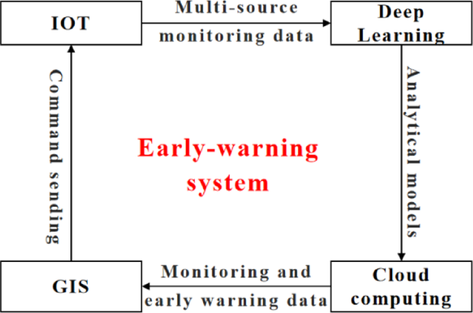
The proposed EWS integrates four core technologies: Internet of Things (IoT), deep learning, cloud computing, and Geographic Information Systems (GIS). Each plays a distinct role in system development:
The IoT is an emerging technology for information sensing and transmission. It connects physical objects with digital networks using sensors and communication protocols, enabling intelligent monitoring and management. Recent IoT advances have significantly improved slope monitoring capabilities. These include multi-source data sensing and real-time transmission, which is crucial for accurate landslide monitoring and early-warning. In this research, IoT technology was implemented for the monitoring of open-pit mine slopes. Monitoring data were transmitted to cloud servers via efficient communication protocols (e.g., MQTT, HTTP), ensuring both data integrity and real-time availability. These real-time reliable multi-source monitoring data are essential for dynamic risk assessment and predictive early-warning of landslides.
Deep learning, a pivotal branch of artificial intelligence, demonstrates significant advantages in complex pattern recognition and prediction tasks. By constructing multi-layer neural networks, it automatically extracts intrinsic features and evolutionary patterns from massive datasets, enabling high-precision predictions for unknown data18. In geotechnical engineering, particularly for slope stability monitoring and early warning, this technology provides innovative solutions for capturing nonlinear, non-stationary data characteristics that traditional methods often fail to address19. This study employs Long Short-Term Memory (LSTM) algorithms to analyze temporal evolution patterns from slope monitoring data, establishing an advanced prediction model for slope deformation.
Cloud computing represents an advanced computational mode that creates configurable resource pools. These pools provide on-demand access to computing resources (networks, servers, storage, applications, and services) anytime, anywhere. This mode significantly reduces resource management workloads and minimizes interaction costs with service providers. It enables rapid resource deployment and release20. This study leverages Alibaba Cloud’s Elastic Compute Service (ECS), a virtual server solution in cloud environments. ECS dynamically adjusts computing resources based on user requirements, ensuring efficient resource utilization. By integrating ECS’s advantages (elastic scaling, efficient management, and high reliability), this research achieves two critical functions: (1) Storage of multi-source monitoring data. (2) Real-time data analysis. These capabilities deliver robust computational support for landslide risk assessment and early-warning.
GIS is an integrated system designed for data acquisition, transmission, management, storage, analysis, and visualization. Their core strength lies in efficient integration and dynamic representation of geospatial data21. Recent advances in 3D modeling, virtual reality (VR), and artificial intelligence have significantly expanded GIS applications in geotechnical engineering. These technologies demonstrate particular advantages in slope stability monitoring and landslide early-warning. In this study, GIS capabilities for multi-source data management and visualization were leveraged to develop a virtual reality scenario for slope risk management. By integrating topographic, monitoring, and early warning data, the system provides a foundation for mine safety management.
The interrelationships among the four technologies are illustrated in Fig. 1. The EWS acquires multi-source monitoring data through IoT technology. Deep learning provides analytical models for data mining, while cloud computing delivers computational power for data analysis and landslide risk assessment. GIS technology enables integrated visualization of real-time monitoring and early warning data, achieving transparent risk representation. Finally, users manage risks via the GIS system and dispatch control commands through IoT technology, establishing closed-loop management of landslide risks.
Fig. 1
Technology composition of the early-warning system.
Framework design for the EWS
The EWS employs a three-tier framework (Fig. 2): data layer, service layer, and application layer. The data layer is responsible for the real-time collection and storage of on-site monitoring data. The service layer handles data processing to meet the requirements of various disaster early-warning procedures. The application layer is dedicated to the visualization of the early-warning process. This structure ensures comprehensive management of the entire landslide risk process – from data acquisition and risk analysis to warning issuance and risk visualization. Key design considerations for each tier are detailed below.
Fig. 2
Data layer
The data layer manages real-time acquisition, transmission, and storage of multi-source slope mechanical response data. This EWS integrates multiple monitoring devices for open-pit slopes. These include GNSS devices, multi-point extensometers, inclinometers, and radar for tracking rockmass displacement. Additionally, crack gauges measure crack width. Blast vibration sensors detect shockwaves from mining operations. These real-time, multi-source monitoring data provide the foundation for comprehensive landslide risk assessment and early warning. Given the significant variations in data structures and acquisition approaches across monitoring devices, the system incorporates tailored data transmission schemes designed for the specific characteristics of each device type to enhance efficiency:
(1)
Point-based monitoring devices, such as GNSS devices and inclinometers, generate multi-channel time-series data. This data type is characterized by small individual packet sizes but high acquisition frequencies. To efficiently transmit this data, the system employs the MQTT protocol. MQTT demonstrates high performance for small payloads, high-frequency communication, and reliable data delivery, making it well-suited for the real-time transmission needs of point-based sensors.
(2)
Radar monitoring offers extensive coverage, high scan frequency, and generates large data volumes per measurement. Following each scan, the radar device locally produces a TXT file containing deformation data. To enable efficient transmission of these substantial files, the EWS employs a combined approach using file system monitoring and the FTP protocol. The file system monitor detects newly generated TXT files in real-time, triggering their immediate transfer to a designated server via FTP. This method ensures both prompt data delivery and file integrity.
Following data acquisition and transmission, the EWS implements differentiated storage strategies based on data types to ensure efficient management and rapid retrieval. For structured data from GNSS and crack gauge sensors, MySQL databases provide optimized storage, leveraging their robust data management and query capabilities. Regarding file-based data generated by radar systems, characterized by large file sizes, the system stores files directly on local disks while using MySQL to record storage paths and metadata. This hybrid approach reduces database load and improves file management efficiency.
Furthermore, to ensure reliable multi-source data transmission and real-time communication, the IoT network within the proposed EWS adopts a 4G-based wireless architecture. Each on-site monitoring device—including GNSS, radar, inclinometers, and crack gauges—is equipped with a data acquisition module and a 4G communication terminal. Monitoring data is transmitted through the public 4G cellular network to the cloud server, where the data layer receives and synchronizes information in real time.
Building on the IoT architecture studies by Dorthi22 and Zhou15, the IoT communication framework adopted in this study follows a three-tier structure comprising the perception layer, network transmission layer, and application layer.
The perception layer comprises distributed monitoring sensors that collect displacement, deformation, and vibration data from slopes in real time. The network transmission layer utilizes 4G communication protocols to achieve long-distance, low-latency, and stable data transmission between field devices and the cloud platform. The use of existing 4G infrastructure ensures high reliability and scalability while minimizing deployment cost. The application layer runs on the cloud platform, integrating real-time data acquisition, storage, and analysis services through the MQTT and HTTP protocols.
To visually clarify the IoT communication process, a network architecture diagram has been added to the revised manuscript (Fig. 3). Monitoring sensors (GNSS, radar, inclinometer, and crack gauge) collect real-time deformation data and transmit them wirelessly to the 4G base station. Using MQTT and HTTP protocols, the base station uploads the data through the 4G network to the cloud platform for data storage, analysis, and visualization. The process ensures real-time synchronization, low latency, and high reliability for continuous slope risk monitoring.
Fig. 3
4G-based IoT architecture for EWS.
Service layer
The service layer functions as the core component of the EWS, enabling intelligent data processing and analysis to support all phases of landslide hazard alerts. It comprises six integrated modules: (1) Equipment management services; (2) Data management services; (3) Prediction and early-warning service; (4) Alert dissemination service; (5) Virtual reality scenario service; (6) Data visualization service. These modules operate collaboratively to establish a comprehensive monitoring and warning framework for open-pit coal mine slopes. The specific functions of each module are detailed below.
(1)
Equipment management service: This service provides full lifecycle management for monitoring devices. Key functions include maintaining essential device information. By intelligent device-system matching, the service ensures real-time data transmission and cloud synchronization. This guarantees continuous and complete data acquisition, delivering reliable data for data management services.
(2)
Data management service: This service handles the storage, maintenance, and retrieval of multi-source monitoring data. It provides robust storage and efficient management capabilities for multi-source data streams. By establishing an integrated data management platform, the service enables standardized processing and rapid querying of monitoring datasets. This infrastructure delivers a solid data foundation for predictive analytics and early-warning services.
(3)
Prediction and early-warning service: This service delivers intelligent forecasting of rockmass mechanical behavior and slope stability. It integrates three core functions: data preprocessing, LSTM-based mechanical response prediction, and Dempster-Shafer evidence theory-driven landslide risk assessment. This integrated framework extracts critical landslide precursors from multi-source monitoring data. By implementing data fusion methods, it resolves conflicts in multi-device warning outputs, significantly improving the accuracy and reliability of slope risk predictions. The service thus provides a quantifiable basis for early-warning decision-making.
(4)
Alert dissemination service: This service manages early-warning alert distribution and administration. It enables flexible configuration of alert dissemination channels and closed-loop management of response procedures. By continuously monitoring slope risk status, the service automatically issues alerts to management personnel when the slope is instability. All response actions are systematically recorded, ensuring automatic alert distribution and full traceability of risk mitigation processes. This provides critical decision support for landslide management.
(5)
Virtual reality scenario service: This service constructs a digital twin scenario of the open-pit coal mine using the SuperMap platform. This system integrates UAV-based oblique photogrammetry to achieve high-precision modeling of coal mine slopes. By visualizing rockmass mechanical responses, the service transparently displays real-time slope conditions and deformation trends. This provides managers with an immersive virtual reality (VR)-enabled visualization experience for operational decision-making.
(6)
Data visualization service: This service converts multi-source monitoring data into computer-readable charts and graphs, significantly simplifying data interpretation. It dynamically displays real-time data while generating historical trend plots. These visual tools help users intuitively understand slope risk conditions. Through interactive visual exploration, the service enhances both the efficiency of slope risk management and the scientific basis for decisions.
Application layer
The application layer serves as the user interface for the EWS. It performs two key tasks: calling services and displaying functions. Designed around user needs, it combines multi-source data, intelligent analysis, and visual tools. This layer manages the full lifecycle of landslide early-warnings for open-pit coal mines, which delivers five primary capabilities:
(1)
VR scenario of open-pit coal mine: Leveraging device management and virtual reality scenario services, this module constructs high-precision reality models using UAV oblique photogrammetry. It enables precise device localization and dynamic visualization within a VR scenario.
(2)
Multi-source data query: A data center is built using the device management and data management services. Users can quickly retrieve monitoring data for specific timeframes and locations. This enables a better understanding of rockmass failure progression in slopes.
(3)
Slope risk prediction: This module integrates data management and Prediction and early-warning services to deliver intelligent risk assessment and prediction. The EWS processes real-time monitoring data through an LSTM-based prediction model. The output is then fused with D-S theory to evaluate landslide risk. This integrated approach proactively identifies potential landslide risks, providing a foundation for mitigation strategy development.
(4)
Multi-Source Data Visualization: This module integrates data visualization and virtual reality scenario services to provide a multi-view representation of multi-source monitoring data. By integrating diverse visualization formats (data tables, trend curves, and heatmaps), the EWS dynamically displays current slope conditions and evolutionary trends. This module streamlines data interpretation while delivering intuitive decision-making support to management personnel, which can significantly enhance emergency response efficiency.
(5)
Multi-channel Alert Distribution: This module integrates predictive analytics and alert dissemination services to generate smart tiered alerts for slope risks. Based on predefined risk classification protocols, it automatically disseminates alerts through SMS, email, and other communication channels. This ensures the timely delivery of critical notifications to relevant personnel, enabling rapid emergency response.
Early-warning methods
Prediction and early-warning methods constitute the core of the Early Warning System (EWS) and are crucial for generating high-precision landslide alerts. As shown in Fig. 4, the integrated workflow encompasses data processing, prediction, and risk assessment. The process begins with the real-time acquisition of rock mass deformation data via monitoring equipment such as radar and GNSS. A scheduled task mechanism, whose frequency is adaptively adjusted based on the identified landslide risk level, is employed for periodic data processing. By default, data are processed once per day, while the frequency increases to once per hour when the risk level reaches “Orange” or higher. Upon triggering, the scheduled task first performs data cleaning using the Pauta criterion, as detailed in Section “Data preprocessing based on the Pauta criterion”, to ensure high-quality monitoring data. The cleaned data subsequently serve two purposes: they are fed into an LSTM model to predict future rock mass deformation (Section “LSTM-based prediction model”), while both the cleaned data and prediction results are jointly analyzed to extract landslide risk evaluation indicators, such as the improved tangent angle, for both current and future states (Section “Landslide risk assessment model based on D-S theory”). These indicators are then fused via the Dempster–Shafer (D-S) evidence theory model, enabling a comprehensive landslide risk assessment and graded early warning, as further elaborated in Section “Landslide risk assessment model based on D-S theory”. Detailed methodological descriptions are provided in the subsequent sections.
Fig. 4
Overall workflow of the early-warning method.
Data preprocessing based on the Pauta criterion
Harsh mining environments with heavy dust and poor network connectivity often prevent monitoring devices from operating consistently. This instability compromises data integrity and reliability.
Incomplete monitoring data primarily stems from transmission anomalies during collection, caused by unavoidable factors like network disruptions, adverse weather, or mining activities. Resulting data gaps alter dataset structures—for example, shortening time-series sequences. Since most analytical algorithms require structurally consistent inputs, such disruptions frequently cause analytical failures, undermining slope risk assessment accuracy.
Given that most devices follow a scheduled acquisition time interval, data completeness is verified against predefined intervals. Let d represent the data measurement interval (in minutes). Every minute, the system initiates a missing-data check. For each check, the time difference (Δd) between the current check time and the device’s last successful data acquisition is calculated. When Δd > d, the device has failed to collect data within its scheduled measurement interval. To address such missing values, the LSTM-based prediction model (Section “LSTM-based prediction model”) is used to predict current mechanical responses. These predicted values are then stored as monitoring data to preserve dataset integrity.
Data unreliability mainly involves outliers from complex environmental interference during collection. These anomalies distort distributions and impair deep learning model performance. Consequently, robust preprocessing is essential for noise removal. The Pauta criterion (3σ principle)23 provides effective denoising using statistical properties of normal distributions, combining operational simplicity with proven efficacy. The Pauta criterion is employed to identify noise by establishing a confidence interval based on the mean ((mu)) and standard deviation ((sigma)) of a dataset, as defined in Eq. (1):
$$[mu -ksigma ,mu +ksigma ]$$
(1)
where (k) is a scaling factor that determines the breadth of the interval. When (k=1,)approximately 68.27% of the data points are expected to lie within the interval; this proportion increases to about 95.45% for (k=2,)and 99.73% for (k=3.)Any data point falling outside this defined interval is subsequently identified and treated as noise. This study implements real-time Pauta denoising within a 7-day moving window—optimized for slope mechanical response characteristics. As new data arrives, the system continuously performs anomaly detection as follows:
1.
For a real-time data point At measured at time t, extract data from the preceding 7 days to form a time-series dataset L = {A0, A1, A2, …, At}.
2.
Calculate the standard deviation (σ) and mean (μ) of dataset L. Determine the confidence interval C for normal data using Eq. (1). Following the Pauta criterion and considering data characteristics, a conservative threshold k = 2 is adopted, retaining 95.45% of normal data for subsequent calculations.
3.
Evaluate At against the confidence interval. Data points within C are classified as normal, otherwise as outliers.
LSTM-based prediction model
Current early-warning systems (EWSs) typically assess slope stability by comparing real-time monitoring data against predefined thresholds. While this approach is effective for evaluating instantaneous stability conditions, it lacks predictive capability and often leads to delayed warnings. In open-pit mines, slope monitoring data generally exhibit nonlinear and nonstationary temporal patterns. Despite their complexity, these deformation sequences frequently contain short-term trends that can be exploited through time-series modeling.
Long Short-Term Memory (LSTM) networks are well-suited for this task because their gated memory structure effectively captures nonlinear temporal dependencies in sequential data24. After data denoising using the aforementioned procedures, the LSTM model is adopted in this study to forecast short-term mechanical responses, thereby providing near-future deformation trends. The workflow consists of four main stages:
(1)
Pre-processing phase: In this study, multiple types of monitoring instruments were deployed, including Global Navigation Satellite System (GNSS) sensors, ground-based radar, inclinometers, and crack gauges. The sampling intervals were 10 min for GNSS, 30 min for radar, and 5 min for inclinometers and crack gauges. The monitoring data are collected continuously and transmitted to the cloud server in real time. Given that monitoring devices collect data at intervals ranging from minutes to hours, their measurements often exhibit significant fluctuations. To mitigate these fluctuations, daily mean deformation values are calculated at the end of each day. These mean values represent the mechanical response of the slope rockmass for those 24 h.
(2)
Model architecture: The proposed LSTM model employs a concise univariate architecture designed for efficient and stable slope displacement forecasting. Each input sample consists of the most recent 10 consecutive daily displacement values, corresponding to an input shape of (10, 1)—ten time steps and one feature per step. The network includes three layers:
1.
an input layer receiving the displacement sequence.
2.
a single LSTM hidden layer with 100 memory units, which captures the nonlinear temporal evolution of slope deformation.
3.
a fully connected output layer with one neuron and a linear activation, producing the predicted displacement for the next day (output dimension = 1).
The LSTM layer uses the standard tanh and sigmoid activation functions for internal gating. This lightweight configuration provides sufficient representational capacity for long-term deformation sequences while maintaining low computational cost, enabling real-time operation on industrial hardware.
(3)
Training phase: For model training, the most recent 40 days of monitoring data are used. A sliding window of 10 days serves as the input, and the subsequent day’s displacement as the target output. By moving the window forward one day at a time, 30 training samples are generated. The model is trained using the Adam optimizer (learning rate = 0.001) with mean squared error (MSE) as the loss function. Training proceeds for up to 100 epochs with a batch size of 10, reserving 10% of the samples for validation. An early stopping strategy (patience = 10, restore_best_weights = True) is applied to prevent overfitting. After each forecast, the predicted value is appended to the time sequence, forming a recursive prediction loop for continuous updating.
(4)
Prediction phase: During inference, the model receives the latest 10 days of actual monitoring data to forecast the next day’s displacement. For subsequent predictions, the model combines the most recent 9 days of real data with the previous prediction to form a new input window, iteratively generating forecasts one day at a time. This process continues until 10 consecutive daily forecasts are obtained, providing a near-term prediction horizon for slope deformation evolution.
Landslide risk assessment model based on D-S theory
Current risk assessment practices for slopes in open-pit coal mines often rely on evaluating single parameters from monitoring data. However, slope failure involves complex mechanisms where analysis based on a single parameter is inadequate, frequently leading to conflicting risk assessments. To address this limitation, we apply Dempster-Shafer (D-S) evidence theory. This systematic framework integrates uncertain information from multiple sources. As an extension of probability theory, D-S quantitatively combines evidence from different indicators while accounting for their individual reliability, thereby resolving contradictions between multi-source assessments. This integrated approach provides a more comprehensive and accurate stability evaluation for slope risk management.
(1)
Evaluation indicator selection and quantification of risk value.
When a slope is undergoing creep deformation, Xu et al.25 proposed that the displacement rate (ν) during the secondary creep stage remains constant. To transform the displacement–time curve’s vertical axis into the same time dimension as the horizontal axis, displacement is divided by ν, as shown in Eq. (2):
$$T = frac{Delta S}{v}$$
(2)
where (Delta S) is the slope displacement. ν is the secondary creep velocity, and (T) is the transformed vertical coordinate value with the same dimension as time. The tangent angle (alpha) of the displacement curve is then defined as the improved tangent angle, expressed as:
$$alpha =mathit{arctan}frac{Delta T}{Delta t}$$
(3)
When α < 45º, the rockmass is in the primary creep stage, and failure is unlikely. When α = 45º, it enters the secondary creep stage. When α > 45º, it enters the tertiary creep stage, indicating a potential risk for failure. This indicator (α) has been widely adopted by researchers internationally26,27. Its effectiveness has been validated through extensive engineering practice, leading to the development of a corresponding four-level early-warning threshold.
Furthermore, based on the report analysis and literature review, cumulative displacement and deformation velocity were selected as additional evaluation indicators. Warning level thresholds for these indicators were established, thus forming a comprehensive slope stability evaluation indicator system. The specific thresholds are detailed in Table 2.
To further quantify the relationship between the different warning levels and the landslide risk, probability ranges for each level were assigned based on previous research28, specifically 0 ~ 0.25 for Advisory, 0.25 ~ 0.5 for Caution, 0.5 ~ 0.75 for Warning, and 0.75 ~ 1 for Alert. Furthermore, relationships linking the landslide risk to each indicator were established through a fitting approach, with the specific mathematical expressions provided in Eqs. (4) to (6). This quantification thus enables enhanced landslide risk assessment and prediction.
$$R_{alpha } = 0.079e^{0.0249alpha }$$
(4)
$$R_{S} = 0.025S – 0.5$$
(5)
$$R_{v} = 0.0556v – 0.2222$$
(6)
(2)
Landslide risk real-time assessment based on D-S theory.
Building upon the above framework, once new real-time monitoring data is received or a prediction is completed, the improved tangent angle, cumulative displacement, and deformation velocity are calculated. The risk level for each indicator is then quantified using Eqs. (4)-(6). Subsequently, the Dempster-Shafer (D-S) evidence theory is applied to fuse the risk parameters derived from these indicators. The procedure is as follows:
In this study, the risk state of the slope is defined within the identification framework Θ = {A, B}, where A represents an unstable state and B represents a stable state. The risk assessment results for the improved tangent angle (Rα), cumulative displacement (RS), and deformation velocity (Rν) serve as the evidence sources. Based on Eqs. (4)-(6), the basic belief assignments are determined. Mass functions describing the slope stability states are then constructed for each evidence source according to the principles outlined in Table 3.
Table 3 Mass function allocation of evidence source.
Based on D-S evidence theory, the three independent mass functions (m₁, m₂, m₃) are fused into a combined mass function using Dempster’s combination rule to obtain the comprehensive probability, Rf, of the slope being in an unstable state (Proposition A). The rule is defined as follows:
The normalization factor (K) ensures that the total probability is unity and is defined as the sum of the products of masses for all non-conflicting propositions:
The value ({R}_{f}) is subsequently classified into a risk level based on Table 4, achieving a data-driven and fused risk assessment.
Table 4 Classification of slope risk warning levels.
Implementation of EWS
The EWS employs a Browser/Server (B/S) architecture. The frontend, developed with Vue.js, Element UI, ECharts, and Cesium, enables real-time monitoring data visualization and slope stability assessment visualization. The backend integrates Maven, Spring Boot, MyBatis, and Python for data management and intelligent analysis. Cloud infrastructure utilizes Aliyun ECS elastic servers and Aliyun RDS MySQL. This architecture eliminates client-side installations—users access the system instantly via any network-connected browser. Domain-based access initiates HTTP requests for frontend-backend data exchange, enabling one-click retrieval and visualization of slope risk state. Figure 5 presents the interface of the developed system.
“As disappointing as this outcome is, it is only a setback and not the end of the journey for this project,” said cabinet member for regeneration, Louise Walker.
“I am looking forward to further discussions with the MP and the National Brewery Heritage Trust to see what support both the government and the brewing industry can offer this important project.
“It is clear that the success of this project will depend on that support before we can move forward with another funding bid.”
The heritage collection from the former National Brewery Centre, which closed to make way for Molson Coor’s new headquartersm would remain in storage through an extension of the lease at a unit on Station Street.
The authority’s leaders said that while their plans for this part of the Old Brewery Quarter regeneration were delayed, work would continue on demolition of the Trent House building and data centre.
Initial work would also start on the new Washlands visitor centre, with a final contract for this development due to be in place by April 2026.
Also due to take place next year are repairs to listed buildings and the start of conversion works for the new Loungers unit at the rear of Bass House.